Place in History
Even though Fort Zarah had a short life, it saw its share of Indian fights and colorful characters including George Armstrong Custer, Wild Bill Hickok, Buffalo Bill Mathewson, Buffalo Bill Cody, Kit Carson, and the great indian chief Satank aka Sitting Bear.
Name
Fort Zarah was named in honor of Maj. Zarah Curtis who was one of 90 Union soldiers killed at the Baxter Springs (Kansas) massacre in October 1863 by Quantrill's Raiders who were disguised as Union soldiers.
Zarah Town
A small town called Zarah grew up around Fort Zarah. At its peak, Zarah had a hotel, two saloons, a blacksmith shop, a livery stable, a general store, a post office, and several homes. Several thousand Texas cattle were wintered there. The town of Zarah is now a wheat field 3 miles east of Great Bend. The last citizen left Zarah in 1875 about 6 years after the fort was abandoned.
The Ranch / Trading Post at Walnut Creek
Fort Zarah was established near a ranch (trading post) where the Santa Fe Trail crossed the Walnut River. The ranch was established in 1855 and was known as the Allison Ranch, the Peacock Ranch, the Rath Ranch, or the Douglas trading post, depending on who operated it. The ranch was destroyed by Indians in May 1868.
More Information About Fort Zorah
( from the Santa Fe Trail Research Site, Larry & Carolyn Mix )
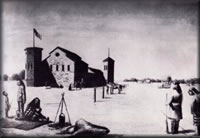
This artist's conception shown above of the last Fort Zarah, Kansas is believed slightly incorrect. If the shadows are correct, then this would be a view from the northeast looking towards the fort and Walnut Creek in the background. The building had only one window, in the east end. The two towers were located on the southeast and northwest corners and were two stories high. The gunslits or loopholes were only 2 inches wide by 16 inches high which doesn't correspond with the drawing above. Also a 14 foot square stone guardhouse stood near the fort on the southeast side, not picture in the above drawing. This is but one drawing of Fort Zarah.
"Military Camp"
On or around, June 1, 1853, Bvt. Maj. Robert H. Chilton and his Company B, First Dragoons left Fort Leavenworth, Kansas for the soon-to-be abandoned Fort Atkinson, Kansas on the Arkansas near present day Dodge City. Accompanying them down the Santa Fe Trail were "teams and citizen teamsters to transport the government property from the Arkansas to the new military camp near the mouth of Walnut creek" as recollected by Perecival G. Lowe, in his 1906 published Five Years a Dragoon, page 128-129.
June 24, 1853; Bvt. Maj. Robert H. Chilton and Company B, First dragoons, arrived from Fort Leavenworth.
June 25, Chilton assumed command of the post. Subsequently, Bvt. Maj. Edward Johnson and Company D, Sixth infantry, departed for the new military camp site on the Walnut Creek Crossing near present Great Bend, Kansas. Orders had been received at Fort Atkinson in mid May directing that the post be removed to Walnut Creek.
July 25, 1853; Sixth military department Special Order of June 28 was received at Fort Atkinson. It directed that all operations at Walnut Creek be suspended.
August 4, 1853, Bvt. Maj. Edward Johnson and Company D, Sixth infantry returned to Fort Atkinson from Walnut Creek.
August 22, 1853, The U.S. Post Office at Fort Atkinson, established November 11, 1851, was discontinued and according to post office department records, reestablished at Walnut Creek with Samuel G. Mason postmaster as before. Post Office records apparently show that the Walnut Creek post office was not discontinued till September 22, 1853. Except for the month of July, 1853, there was no military camp at Walnut Creek during the 1853-1855 period. Was the post office discontinued, rather on September 23, 1853, the date of Fort Atkinson abandonment? In the book "1001 Kansas Place Names" It states; "There are twenty-seven Walnut Creeks in Kansas. Santa Fe Trail surveyor George Sibley noted the creek in 1825, and travelers on the Santa Fe Trail often camped at the Walnut Creek Crossing. In the 1850's William Allison and Francis Booth established a trading ranch at the crossing, selling supplies and provisions to travelers. The Kiowa called the creek Tsodalhente-da Pa, or Armless Man's Creek, for William Allison who had only one arm. Post Office August 22, 1853, November 20, 1857
This is the only record that has been found on this Military Camp at the Walnut Creek Crossing and it's post office. It stand to reason that if orders came down for a military camp to be established at the Walnut Creek Crossing site then this would have been the place that could be called Fort #1 even though it never had a name that can be found, all of them are in the same area and did the same thing. There are dugouts straight south and east of the bend in the creek that is believed to be the dugouts used by the first troops that came to Walnut Creek in 1853. Around these dugouts the relic's that are found are mostly of this time period, musket balls and not minnie balls of the later period. Also the military relic's are of this time period. The crossing was to the west of the Camp or Fort location.
The first fort at Walnut Creek Crossing was just a simple "military camp" and was no more than several dugouts built of adobe and logs with a mud roof.
"Camp Dunlap"
Camp Dunlap is a different story all together. There are records of what it was called. It was located approximately 30 miles east of Fort Larned, Kansas and was established by General S. R. Curtis on July 28, 1864. The fort was only dugouts and tents located on and in the creek bank. This fort was under the commanding officer of Fort Larned and made it's reports to that officer. This second fort on the Walnut Creek was first called Camp Dunlap. The second set of dugouts can still be seen to this day, and are located about a quarter of a mile up the creek from the first set. This Fort sat to the west of the crossing of the creek. These dugouts are located straight west of the present day house on and in the far northern bend of the Walnut Creek. There are several dugouts that have been dug out and "left open" by the Kansas Historical Society and the local digging club in the Great Bend, Kansas area.
The First Fort Zarah
The name was changed to "Fort Zarah" in July of 1864. In February of 1865, the newly arrived Second Colorado Cavalry was put to work building an octagonal blockhouse of stone. A small building with a walkway across the top was built at this location. The location of this building is north of the Crossing of the Walnut Creek.
"Fort Zarah" was first abandoned on April 7, 1866.
The Second Fort Zarah
The order to re-establish "Fort Zarah" came through in June of 1866.
It was rebuilt of "sandstone with a tin roof" approximately one-half mile north/northwest of the previous location, and was completed in 1867. There were five square miles which were declared the "Fort Zarah Reservation" in December of 1868, when it was declared an independent post.
Fort Zarah was finally abandoned in December of 1869.
To the stranger seeking information about "Fort Zarah, Kansas" the battle is long and all uphill. The first big discovery is that the fort didn't stand at but was very near the present Fort Zarah park site. The second bit of information a person gleans is that the fort was actually on the east side of Walnut Creek, and the third is that practically no one can actually pinpoint the ground where the fort once stood.
The research for this progressed through the steps mentioned above and a few others, before finally finding the exact location. Early written accounts concerning the location either referred to the "well-known location of the fort" or pinpointed it by section, range and township numbers only. This will only get you close to the location. This doesn't help to much when you're trying to locate the spot where a building 50 feet wide by approximately 130 feet long once stood.
The first break in finding the location came through conversation with Mr. Schulz, local Great Bend historian and president of the newly formed Barton County Historical Society. Ray had never walked over the area but said he knew right where it was.
A drive to the spot and he pointed out it is three-tenth of a mile east of the Walnut Creek bridge on U.S. 56, just that far east of the park site entrance. A walk north of the highway out into a plowed field for about 40 yards where you can found a distinct change in the color in the plowed earth, indeed a white line about three feet wide and approximately 90 feet long which Ray was sure was the south edge of the fort location . Ray seemed to think this white "line' was due to some clay formations that some how linked with the remains of the south wall of the fort. Running north off this line was another distinct line which ran 40 to 50 feet north which would then indicate the east wall of the fort. There was a north-south line on the west edge of this partial rectangle but it was not straight. Instead it fanned out in a half circle.
Disturbing was the fact that only several yards from this site in the same field to the east another fanned-out line of white earth and clay was clearly distinctive. Since it is kown that the fort consisted of only one sandstone building and a stockade south of the fort; there was no particular connection to this partial rectangle that we viewed as the "floor plan" of Fort Zarah.
However, once inside this rectangle we found with no effort, many pieces of sandstone, some with the white mortar still attached. Ray also picked up at least half a dozen of the large square nails or spikes as they were known at that time. This evidence convinced this writer we had found the location of the fort.
Additional nails, sandstone and several pieces of thick, greenish glass which with out a doubt were parts of old bottles. Some old crockery was also found.
Soon after this, information came to light that a man who once farmed the land was still living and could be reached. This man was Mr. Johnson, of Great Bend, Kansas, whose father purchased the land from a family by the name of Fry in 1900. Mr. Johnson said that at that time the sandstone foundations of the two cellars and the magazine were still intact although there was not much else left. The one exception was many pieces of heavy tin, parts of the roof that had not been moved when the fort was dismantled. He said that the heavy pieces of tin were hauled to the river and dumped since they were mashed in, bent, and not useful. Some of the pieces were later buried when he and his father filled in the cellars.
Mr. Johnson said that he and his father used the cellars for cow barns for awhile, after constructing a make shift roof over them.
When asked if he had ever found anything that would indicate a fort once stood on the location, Mr Johnson stated that he had found several small coins, one bearing an 1864 date. He said another person had found a 2 1/2 dollar goldpiece near the fort, bearing the date of 1849. He said he and his father discovered that someone had removed a sandstone in the magazine and had found hidden there seven cardboard cartons of army cartridges. He said they later buried these shells when they filled in the fort ruins with dirt.
It was with this information it was dicided that this must be the location of the old fort. Mr Johnson stated that about the only thing left at the old fort site to be picked up was sandstone, old nails and parts of broken bottles might be found there. He said the bottles were exceptionally thick, perhaps half an inch, and that most of them were green in color. He related that he had found minne shot or balls evidently used in cap and ball weapons. He also had once found a heavy horse bit with U. S. stamped thereon.
Mr. Johnson related that he had found a white rock with a regiment inscribed on it at a location 400 to 500 feet to the northeast of where an old house once stood just east of the fort location. A white frame house now sits at the same location. He said he hauled the stone into near the house but didn't remenber what happened to the stone. It may still be there for some one to stumble onto one day.
Although Mr. Johnson indicated the white clay at the spot of the fort had nothing to do with the location, we were convinced of the authenticity of the location. He stated the clay was merely a layer that happened to be there and uncovered by bulldozers when U. S. 56 was built. He stated that the bulldozers removed at least 18 to 20 inches of topsoil from the fort site and put it into the highway.
A final clincher on the location came when Mr. Johnson told us the fort location was surrounded by a slight depression or draw. This depression or "creek" has been referred to in writings and was clearly distinguishable on the spot although it is not deep.
With the location pinpointed, the only thing left was to gather and assemble the history of the fort. This at first seemed it would be easy. But like the location problem, it was found that an accurate history of Fort Zarah was not easy to come by. Tales of this and that are still told in Barton County and diaries and other stories concerning the early life near Fort Zarah are available, but nowhere can be found any sort of true history of what went on at the Fort.
This is evidently due to two reasons; first the Fort was built in 1864 an early year for this area, and it was dismantled in 1869, three years before Great Bend became a town. Thus the history was well over before most settlers arrived in this territory. Secondly, of all the tales and facts concerning the history of the fort that were available back in the 1870's and later, only a few were ever put on paper.
Mr. Schulz tells us he has microfilm of records completed at the fort, but that they contain mostly rosters and rolls. Many books written about Kansas mention Fort Zarah, but few elaborate. Most tell of passing the fort or some particular battle with the Indians near the Fort's location, and a letter to the National Archives produces little of nothing about the Fort.
A book, "75 Years in Great Bend", by the Tribune Publishing Company in 1947, reveals that "records of the General Land Office in the National Archives show that the former Fort Zarah Military Reservation contained 3,247.60 acres of land in Townships 19 South of Range 12 West and 19 South of Range 13 West.
A Kansas Historical Marker located on the grounds of the park called Fort Zarah Park reads;
"In 1825 The Federal Government surveyed the Santa Fe Trail great trade route from Western Missouri to Santa Fe. Treaties with the Kansas and Osage Indians safeguarded the Eastern end of the road but Plains tribes continued to make raids. Fort Zarah at this point was one of a chain of forts built on the trail to protect wagon trains and guard settlers. It was established in 1864 by Gen. Samuel R. Curtis and named for his son, Maj. H. Zarah Curtis, who had been killed in the Baxter Springs Massacre Oct. 6, 1863. The fort was built of sandstone quarried in nearby bluffs. Fort Zarah wassuccessfully defended against an attack by 100 Kiowas on Oct. 2, 1868. It was abandoned in 1869".
The land was first offered for sale to the highest bidder at "public outcry" at Salina, Kansas, on July 28, 1874. Thomas L. Morris of Barton County purchased the first tract sold, 45.20 acres and paid $4 per acre.
Volume 6, Kansas Historical Collections, page 463, 1901/02 in a history by Henry Tisdale, says: "1864--The next summer the Indians stole our horses, burnt the ranch and killed the stock tender. After that the government sent some soldiers, one company to a point near where the Walnut creek empties into the Arkansas River, and called it Fort Zarah. Zarah was on the bottom of the Walnut and Arkansas rivers. There was one road up the Arkansas bottom which passed close to the military camp. Another road passed near the bluff and crossed the Walnut about a mile up the stream from the military camp, or Fort Zarah".
In 1912, the Tribune publishing company published a book on Barton County Story on Fort Zarah, it said: "The site of the fort is well known to all at the southeast of the Walnut Creek. It stood on a gentle eminence, nearly surrounded by a shallow creek which might easily be made a means of defense by filling with water."
The fort was built of sandstone quarried from the bluffs about three miles to the north. These rocks were mostly of a deep purplish brown, varying to a light brown. They were usually hewn to a pretty smooth face and laid up in the rough in good solid mortar. The outer walls were about 16 inches thick, the inner walls one foot. The walls inside were all well plastered. The roof of the building was of tin, 116 feet, with an average width of 50 feet. The main portion was divided into 7 rooms, some what resembling a "hop scotch" bed. It was two stories high except 24 feet of the eastern part. The main entrance was at the eastern end, opening into the officers quarters. There was only one window in the entire building and that was at the eastern end. There were loopholes along the northwest, and south sides. At the southeast and northwest corners there were hexagonal, two story towers, with two sets of loop-holes were arranged in sets of three on a side in each story, and presented a face opening of two inches wide by 16 inches high, widening in the wall to a breadth of about sixteen or so inches on the inside. Beneath the rooms running across the width there were cellars dug eight feet deep and walled with stone. To the west, at a distance of twenty feet, was the magazine, which was twelve feet square, and connected with the west cellar by an underground passage four feet wide. A short distance to the southeast of the fort stood the guard house, a stone building about fourteen feet square.
Fort Zarah Military Reservation was established September 30, 1868, by order of the president and surveyed and laid out the same year. It is about two by two and three quarters miles in extent, and reaches from the railroad north to the hills. It contains about 3,698 acres. (Discrepancy here?)
On February 24, 1871, an act of Congress provided for bringing into market the lands of the Fort Zarah Reservation; and on August 11, 1871, "the Surveyor General was authorized to extend the lines of the public surveys over the same".
In July, 1874, "the lands having been appraised at from three to ten dollars per acres," where offered at public sale at Salina, at which sale only two lots, containing together, 45.20 acres, were sold at four dollars per acre, leaving the balance subject to private entry at the appraised value".
October 6, 1869, only five years after its establishment, Special Orders No. 185, Department of the Missouori ordered the complete abandonment of Fort Zarah. The post had outlived its usefulness, the Indians were gone, never to return. Captain Nicholas Nolan, the last commander, sent the following reply to Brevet Colonel W. G. Mitchell.
Special Orders No. 185 Current series Dept. Mo. has been received by me, but the transportation required will exceed the supply now at Fort Harker, Ks. if the Commanding General designs the dismantlement of the Post, and transfer of all public property, including roof and flooring, etc. now at this post.
The roof is of tin and very valuable and the flooring has been all placed within two years, and the almost new, and both can be used with the windows again, without any expense except transportation and the necessary mechanical aid which I can supply from my troops; and in my estimation if the Post be left in status quo it will become a rendezvous for horse thieves and prairie robbers.
The Fort was "dismantled" in 1869. Brevet Lieutenant General L. A Easton, Chief Quartermaster of the Department of the Missouri directed in instructions for the removal of all "serviceable material' from Fort Zarah to Fort Harker. All public buildings were dismantled by Captain John Rodgers of Fort Harker. Among other work of dismantling was the removal of the tin roof which first cost the government $20,000 to install, and the removal of the same to Fort Harker at a further expense of $10,000, According to B. B. Smyth, this created fat jobs for some poor contractors. On arrival of the tin roof at Fort Harker, the receiver refused to accept the tin roof, so the tin roof was dumped down on the prairie a short distance from the fort and it has since done good service in sheltering various settlers on government lands. The original cost of Fort Zarah was $110,000.
After the abandonment of the Fort it became a den of thieves and general rendezvous for bats and marauders. These occupied it day and night by turns, the former hiding by day, the later by night.
Settlements comenced in 1871. Almost immediately the hand of the granger was laid upon it, and it began to disappear little by little. Capt. E. V. Rugar was appointed marshal to take care of it, which he bravely did by going to California in 1874, and letting the fort take care of itself.
Shortly after the sale of the lots mentioned above. Mr. E. C. Sooy put up a notice forbidding anyone to remove any rock from Fort Zarah, as the property had been purchased and now belonged to private individuals. The notice held good until all the best rock had been hauled away from the fort by various parties of Great Bend, who made quick work of it for a short time, when the rumor was spread that there had been no sale, and the valuable stone remaining at the old fort lasted but a short time after and today only a heap of rubbish, overgrown with rank weeds is left to mark the spot where the proud fort once stood. Fort Zarah had passed into history.
More about the Fort Zarah area.
In 1868, Indians were very troublesome to the settlers and ranches in the country at that time. They would attack ranchers and wagon trains, run off the horses and cattle and some times kill the people.
On or about the 12th of August 1868, word came to Fort Zarah that the Indians were murdering the settlers on the Saline, and Col. Benteen, with his company of 7th Cavalry "marched swiftly" to their relief, and ran the Indians about ten miles.
On October 2, 1868, Gen. Hazen reports that "about 100 Indians attacked the Fort at daylight, and were driven off; then they attacked a provision train, killed one of the teamsters, and secrued the mules from four wagons; then attacked the ranch eight miles below (near Ellinwood) and drove off the stock".
On the 10th, Lt. Kaizer, 3rd Infantry, reports that "at 4 p.m. a party of Indians surrounded and drove off six horses and two mules from citizens near Fort Zarah, Ruins.
The book also states; There are many evidences of occupation surrounding the fort, such as cellars, remains and traces of ranches, huts, shanties, tents, etc. On section 36 township 19 south, range 13 west about 100 rods south of the southeast corner of the reservation near where the old toll bridge crossed the Walnut, appears the most formidable ruins of any. At first sight there would seem to have been a fort there once; but it must be remembered that in those days, heardsmen were obliged to build for defense. Besides the "oldest inhabitant," Mr. H. H. Kidder, assures us that there was never a fort there only a ranch. The main building is 70 feet north and south, by 30 feet across. A cross wall divides it into two rooms, the north one being thirty feet square, the south one is thirty by forty. There are still some very heavy rocks in the foundatin of the walls, though most of the material of which the walls were composed has long since been carried off. The debris is still 18 inches to two feet high. Attached to the southeast corner appears a hexagonal ruin of earth and rock each of the sides about 12 feet long. On the west side of the building are earth works, about 60 by 80 yards, with various cross works and walls. These were the walls of the corral, which was diveded into appartments. The present owner of the ground has some field crop growing over the ruins; but it seems like farming under difficulties, for the soil is not rich and damp as ordinary prairie soil.
About 300 yards northeast of the ruins, in Section 31, Township 19, Range 12 West, is the old grave yard. This bears evidence of more recent use. There are about 18 or 20 graves in all; though many were difficultto distinguish, and there may be more or less. many of the graves have no stone or stick to mark the spot, and can only be detected by a slight ridge or depression. Several have sandstones raised at the head and foot.
Only one grave has a stone with any inscription. This, a brown sandstone, is broken down and bears the following well carved but partly effaced, inscription; "In Memory of Charles Welch. Who Died Mar. 22d, 1872. Age 1 yr and 2 Months". The age was the most defaced, and may have been somthing else. At the foot a neat cross is engraved on a standing brown sandstone. The grave is covered densely with buffalo grass, and appears much older. At the foot of one grave there is a cottonwood board, witout any inscription. At the heads and the feet of a few, small stones are stuck in the ground.
Three of the graves, which are probably those of soldiers, are surounded by stone walls 18 inches high which are filled within with earth. These are in the best condition of any of the graves.
A personal experience by Homer H. Kiser of Great Bend, Kansas told of the following. "(In the fall of 1867) Fort Zarah was built and occupied by troops. During this same fall, a short distance this side of Walnut Creek four government teams loaded for Fort Larned were attacked by Indianns who succeeded in killing and scalping the drivers and running off the stock. The Post Commander, thinking it not a safe place for him, kept his quarters and gave us what we could get out of the wreck. We went out and made a nice haul of coffee, sarerkraut, beans, flour, and sugar.
"Cow Creek crossing had many a fight between freighters and Indians, and many killed on both sides. Once, when a small party (three men and one woman) with an ambulance, were going to Fort Harker, they were attacked about a mile east of Cow Creek crossing, they stopped over a deep buffalo wallow, and all got down into it for protection. While in this condition a company of troops commanded by a captain who had been sent to look after them, came upon the west bank of Cow Creek in plain view of the scene and after looking at them a few moments, turned his command around for the west without attempting to render them any assistance. One sergeant in his company begged the captain to cross the creek and relieve them, but instead of so doing the captain put the sergeant under arrest and returned to Fort Zarah with his company, thus leaving the small party to perish at the hands of the red devils, which they most certainly would, had it not been for the timely arrival of a dozen scouts on their way from Fort Harker to Fort Larned, who arrived on the spot just as the deserted party had used their last shots at the Indians. They killed three or four Indians and on the other hand the Indians wounded the entire party. The cowardly captain was dismissed from the service for the act."
In 1933, the U. S. Army sent a crew that dug up several old soldier's graves near Fort Zarah. An interview with a Mr. Funk, one of the men concerned in April 11, 1935, revealed the following information.
"I happened to be with Major Cockrill from Fort Riley, Nov. 14, 1933, when he with 12 men from the unemployment ranks searched for the remains of 8 bodies of soldiers, who were stationed at Fort Zarah, military post, established in 1864, three and one half miles east of Great Bend, Kansas, for the purpose of protecting the traders and emigrants from the Indians while on their way to western country. We had been digging for some time without finding any trace of the graves when Andy Ruble spoke up and said, George I tell you, you are to far east. I have herded cattle out here over every inch of this ground and I remember well where those graves were located. I reported this to the major and he said 'Might as well dig over there as any where, we're not finding what we want here" So the men begin to dig cross trenches where Ruble directed. Sure enough in a short time we came to the first skeleton and by carefully brushng the dirt aside we could ge a pretty good idea of how they had been buried. The work continued until seven of the eight bodies were unearthed.
Pieces of wood found near all but one of the bodies indicated that they had been buried in boxes probably made at the fort. The one soldier has no doubt been buried in haste because he had been rolled in a blanket. The army buttons, bits of blanket and pieces of blue soon faded to dull brown and crumbled away.
The lock of hair and scalp marks showed that six of them had been scalped. The bone and a hole in the fractured skull lead us to believe that he had been killed by the Indians and attacked with a tomahawk.
I remembered an account given in Inman's History of Santa Fe Trail, so I immediately went to the library and re-read the account on pages 453 and 455 and reported it to the Major. Word from the War Department informed Major Cockrill that George L. Gardener, private 3rd Wisconsin Cavalry, unassigned recruit, was killed by the Indians near Fort Zarah on November 22, 1864.
In this grave we found a one half dime piece with a hole in it bearing the date 1837 which led us to believe that he was 27 years old, which was about the average age of the soldiers. You see, it was quite a fad in those days to carry a coin either in a pocket book or on a string tied about the person's neck. The war records showed that the following had been buried near Fort Zarah:
Charles Dorherty, Private, Co. C, 2nd Colorado Cavalry March 1, 1865.
Joseph Kuhn, Private Co. C, 2nd Colorado Cavalry March 30, 1865.
James L. Graves, Private Co. C, 2nd Colorado Cavalry, March 1, 1865.
James Graham, Private Co. G, 7th Iowa, September 8, 1865.
Casper R. Leach, Private Co. I, 14th Mo. Cavalry Volunteer December 11, 1865.
Thomas Z. Simms, Private Co. M, 13th Cavalry R. Mo. Volunteer December 11, 1865.
Edmund Gillman, Co. C, 3rd U. S. Infantry July 24, 1865.
However there was no way of knowing the identity of the men. Each skeleton was packed in a separate box and shipped back under government supervision to the national cemetery at Fort Leavenworth for burial. The bodies were found and in this position laying North and South, there were four graves a blank space and then one grave. In the second row there was one grave, it was inline with the blank space in the first row. The missing space may or may not have been the grave of the 8th soldier whom we could not locate. They had all been buried with their heads to the west except the fourth from the south, which was headed east.
Inman's Book, The Old Santa Fe Trail, carries this account which may be the book referred to by Funk:
"Captain Conkey's command returned to the cantonment about midnight. But one Indian had been seen and he was south of the Arkansas in the sand hills.
The next morning a scouting party of 40 men, under command of a sergeant, started out to scour the country toward Cow Creek, northeast from the Walnut.
. . .The scouting party had proceeded about 4 or 5 miles, when one of the corporals asked permission for himself and a recruit to go over to the Upper Walnut to find out whether they could discover any signs of Indians.
While they were carelessly riding along the big curve which the northern branch of the Walnut makes at that point, there suddenly sprang from their ambush in the timber on the margin of the stream about three hundred Indians, whopping and yelling. The two troopers, of course, immediately whirled their horse and started down the creek toward the camp, hotly pursued by the howling savages." On the way to the fort the recruit was having trouble with his horse, due mainly to his jerking and pulling of the bit. The corporal heard his companion cry out as he was speared by an arrow and quickly killed and scalped. The corpral made it back inside the fort soon after and reported the affair.
Inman then writes: Captain Conkey immediately ordered a mounted squad, accompanied by an ambulance, to go up the creek and recover the body of the unfortunate recruit. The party was absent a little over an hour and brought back with them the remains of the dead soldier. He had been shot with an arrow, the point of which was still sticking out through his breast bone. His scalp had been torn completely off and the lapels of his coat and the legs of his trousers carried away by the savages.
He was buried the next morning with military honors in the little graveyard on the bank of the Walnut, where his body still rests in the dooryard of the ranch"
An article appearing in the Daily Tribune Febuary 6, 1933 related aditional information on George Funk and Fort Zarah:
"Rotary Monday noon had as its speaker, George Funk, who told of this section of the country and its relation to the early history of the western part of the country, and he was one of the most interesting speakers.
His part as undertaker who helped Major McFarland, of the U. S. Army find the graves of soldiers who were buried in the Fort Zarah Reservation, brought out the fact that for many years he has been a delver into history pertaining to the Santa Fe Trail and this particular part of the country."
The article then relates that in 1864 a Captain Booth and Lt. Hollowell stayed overnight at Fort Zarah on an inspection tour of Forts Harker, Hays, Zarah, Larned and Dodge and were attacked the next morning about where the courthouse now stands in Great Bend, Kansas. The two officers made it back to the fort with the Indians in hot pursuit and probably owned their lives to throwing out their suitcases. The Indians stopped and cut open the cases, allowing the officers to escape.
The article then continues: "The next day it appeared that the Indians had gone, soldiers were sent out from the Fort to reconnoiter. One officer asked permission to scout along Walnut Creek and a running fight occured in which the recruit was killed and scalped but the officer got to the fort safely. The next day the recruit's body was taken by soldiers and given burial at the fort. When the bodies of the soldiers were found recently on the fort property one of the skeletons had an arrow-head imbedded in the shoulder blade and it was doubtless this recruit, Gardner.
It is the policy of the government to find these forgotten graves and to remove the bones to the military burial grounds at Fort Leavenworth, Kansas and elsewhere rather than to try to preserve the old spots. Major McFarland stated while here he intended to come back when permitted and find other bodies of which there are no records. Finding the spot where records show eight men were interred was difficult and many old timers insisted the spot found was not the right one, that they had been there and knew. Ditches were dug in making the search and the bodies found at a spot some forty or fifty feet from where expected.
Near the Courtney Harris house are the graves of 19 teamsters who lost their lives in an Indian fight. Major McFarland stated that the records show this and also that just west of Walnut Creek bridge on the old trail, a white officer and black trooper are buried and in another place close by two officers were buried.
From the:
Santa Fe Trail Research Site
Larry & Carolyn Mix
St. John, Kansas
© "Forever"