1500-1825 Kansa Indians inhabit the region including Wakarusa Bottoms at the time of initial European contact by French traders and remain in control of the area until 1824 when they cede the land to the U.S. Government. One Kansa village is located near Eudora. It has been said that the Kansa considered Mt. Oread and the Haskell-Baker Wetlands to be sacred.
1843 Oregon-California Trail opens along western edge of Haskell-Baker Wetlands in 1841 but the first Great Migration begins in 1843. Despite claims to the contrary by the Kansas Historical Society, a depression caused by thousands of wagons, is clearly visible from aerial photographs. The depression, with its greater capability to collect and hold water, necessarily produces a different type of vegetation outlining the route of this national historic trail.
1883-1902 Starting with 280 acres in 1883, the Haskell campus grows to 1,011 acres by 1902. The Bureau of Indian Affairs (BIA), once an arm of the U.S. Army, acquires the Haskell Farm (Haskell-Baker Wetlands) to be used for agricultural training of Indian students.
1884-1934 Haskell Institute is a virtual concentration camp as Indian children as young as four years of age face systematic brutalization and are subject to unsanitary and harsh conditions. According to extensive research conducted by HINU students in the National Archives, up to 700 children die from disease and even gunshot wounds and many are secretly buried in unmarked graves in wetlands.
1920 The Wakarusa-Haskell-Eudora Drainage District, which Haskell Institute joined in 1909, builds a levee and channel in Leech Creek to drain the wetlands for agriculture, to control flooding and to provide irrigation for the Haskell Farm. However, approximately 50 acres of virgin wetland prairie escape the plow.
1920 By 1920 sweat lodges are built on the Haskell Wetlands by students seeking to practice their traditional religion. Students conduct spiritual ceremonies and secretly meet their parents on the wetlands (in violation of school rules). According to a position paper by Haskell, the sweat lodges and Medicine Wheel Prayer Work do not make the land sacred, rather they are located on this land because the land and water in this area are sacred. This area provided generations of early-day Indians and later Haskell students the isolation, solitude and a sense of place that is so important for American Indian spirituality.
1935 Beginning in 1935 farming operations on the Haskell Farm are scaled back and the land is leased in the late 1940s to area farmers for haying.
1953 Congress passes Public Law 47 which provides the exclusive legal method of transferring "Federal Indian School Property", up to a maximum of 20 acres per recipient. This limit is increased to 50 acres in 1962.
1950s Several 20-acre tracts of "surplus" Federal Indian School Property (primarily wetlands) are transferred to various public agencies, including KU and the State Forestry, Fish and Game Commission (now Dept. of Wildlife and Parks). In just a few years, Haskell loses more than 70 percent of its campus with the BIA signing on the bottom line every time.
1957 KU Prof. E. Raymond Hall, director of the State Biological Survey, proposes in a July 15, 1957, letter the transfer of the Haskell Wetlands to the Bureau of Sport Fisheries and Wildlife and that the State Biological Survey be granted "custody of and administer the Haskell Wetlands." In a "scientific" paper previously published Dr. Hall theorizes that a race (subspecies) from the larger landmass ( Europeans from Eurasia) will always dominate the territory of a race from a smaller landmass (American Indians from North America).
1958 The BIA, in collusion with KU Professor Dr. E. Raymond Hall, assigns 573 acres of land (Baker Wetlands) to the Bureau of Sport Fisheries and Wildlife. The State Biological Survey is given management authority. The transfer is clearly illegal, (if not in 1958 then in 1968 when it is ultimately transferred to Baker Uni.) and in violation of the 1953 Public Law because the total amount of acreage transferred is greater than 20 acres.
1958 A July 14, 1958, letter from the Muskogee Area Office of the BIA to KU Chancellor Murphy, points out that 21.71 acres of land had been proposed for transfer to KU but the maximum amount that can be granted under law is 20 acres.
1961 The U.S. Dept. of Interior designates 12 buildings at Haskell and 16 acres immediately surrounding them as a National Historic Landmark on July 4, 1961. In 1996, Haskell requests an amendment to its nomination application to include Traditional Cultural Property extending to the Wakarusa River (which includes the Haskell-Baker Wetlands).
1966 Bureau of Sport Fisheries and Wildlife officials offer to return the wetlands to Haskell, but the Area Director of the BIA in Anadarko, OK in an August 11, 1966, letter states that there is no interest in re-acquiring the land. This is the final BIA word on the matter and the BIA therefore forever forfeits any right to hold title to the land.
1967 Senator Frank Carlson announces April 13, 1967, that 573 acres of the Haskell Wetlands have been assigned to KU for research and educational purposes. However, the actual transfer is mysteriously aborted at the last minute and no deed materializes.
1968 After the mysterious aborted attempt to transfer the 573 acres to KU the previous year, the wetlands are granted to Baker University on September 21 with a deed restriction requiring the land be used only for educational purposes and granting the U.S. Dept. of Education oversight until August 30, 1998.
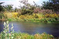
1969 The Dept. of Interior designates the Baker Wetlands a National Natural Landmark in June. The Federal Register describes the landmark as "Undisturbed examples of wetland prairie, and breeding ground for pintails, mallards and Canada geese." The designation highlights 50 acres (in two tracts) comprising the "largest remnants of wetland prairie in Kansas" with "several species of native plants and some species of native animals (that) are now known in Kansas only from the 50 acres of virgin prairie." Although not observed for many years, the wetlands may still be prime habitat for the elusive and rare northern crawfish frog, now officially designated as a "species in need of conservation" in Kansas.
1970 The Wakarusa Watershed District builds a large drainage ditch along the western boundary of the Baker Wetlands (Louisiana St.). This reduces the amount of water flowing into the wetlands and makes the Leech Creek Canal unnecessary for drainage.
1971 The State Highway Commission recommends in its Lawrence Area Transportation Study a South of the Wakarusa River route for a bypass around Lawrence. Later this route is recommended in Plan 95, the comprehensive land-use plan for the city. The officially-recommended route would avoid the wetlands altogether.
1971 The BIA grants Douglas County a right-of-way for 31st Street on May 5, 1971, across the Haskell Wetlands. The road bisects the wetlands and fragments wildlife habitat. Interestingly, Haskell receives no money for granting a perpetual easement of 24 acres of wetlands.
1977 The Wakarusa River is impounded by Clinton Dam, preventing the regular spring flooding of the wetlands. Although the river still occasionally floods into the wetlands, the natural recharging of the wetlands is much diminished.
1985 Early in 1985, a series of Chamber of Commerce Transportation Committee meetings are held in private with county commissioners and a proposal for a southern bypass is then approved in public by the County Commission. In attendance at the secret meetings are those associated with two concrete companies, one construction company, one equipment supplier, Landplan Engineering, a realtor with a 145-acre housing development near the original bypass route, the attorney who later receives the right-of-way acquisition contract and all three county commissioners. Although the District Attorney finds the commissioners probably violated the Kansas Open Meetings Act he merely tells them not to do it again.
1985 On June 7, the Douglas County Commission announces plans for a $3.5 million bond issue. Using its home rule powers, it attempts to avoid a public referendum on the bond issue as required by state law.
1986 The Chamber of Commerce convinces the Douglas County Republican Party Committee not to oppose the re-election of County Commissioner Nancy Hiebert, the SLT's chief cheerleader who participated in the Chamber's secret meetings to plan the road. So, in a last minute campaign, a fictitious frog, Agnes T. Frog, representing the elusive northern crawfish frog listed on the state threatened species register (critical habitat is designated at the wetlands, but later Rana areolata circulosa is downgraded to a "species in need of conservation"), wins 27.5 percent of the vote in the colorful write-in campaign which is reported internationally.
1986 The Committee to Elect a True Amphibian (CETA) forms to run the Agnes the Frog campaign. Later it runs a behind-the-scenes campaign to save the wetlands by ensuring that the National Environmental Policy Act is strictly adhered to. A local banker calls the employer of a CETA officer and urges the employer fire the employee or the entity would face a funding boycott. The employer ignores the request.
1986 Landplan Engineering principal Brian Kubota is formally investigated by the Federal Highway Administration (FHWA) upon complaint by citizens for a conflict of interest regarding preparation of the Draft EIS. Under the NEPA rules a preparer must file a disclosure statement affirming s/he had no "financial or other interest in the outcome of the project." Kubota owns land in the University Corporate Research Park near the original route of the trafficway and his firm has many clients, such as mega-developer Bob Billings. Billings stands to make millions from his development near the trafficway if he can get easy access to K-10 and I-70 for homebuyers who commute to Johnson County and Topeka. In fact, Kubota prepared Billing's Master Plan for West Lawrence. The SLT is crucial to development of the area and will provide additional business for Landplan. Kubota ends up filing a disclosure statement but the FHWA doesn't disqualify him from preparing the EIS nor does it find the EIS fatally flawed .
1987? Even before the first nine miles (two lanes of a four-lane road) of the South Lawrence Trafficway (SLT) were constructed, there were casualties arising out of the trafficway. The first casualty comes when three landowners (Charles Dunbar, Bruce Snodgrass and a third party), along the proposed 31st Street alignment, anticipating increased land values created by SLT access, illegally fill in wetlands in three locations. Unfortunately, the Corps of Engineers sprinkles holy water on these environmental crimes by issuing after-the-fact Clean Water Act 404 permits (plus requiring payments to help restore nearby wetlands). The Corps could have slapped them with heavy fines and required them to remove the fill plus restore the wetlands. With this loss of wetlands and the proposed destruction of wetlands along the SLT 31st Street alignment, the "salami effect" comes into play: a slice here, a slice there, and soon the entire roll is gone. The same applies to loss of wetlands habitat: a tract there, a tract here, and soon a wetlands is so small and degraded its natural integrity is gone and it is no longer a functioning ecosystem.
1987 Due to the power of Senate Majority Leader Bob Dole, Congress allocates $10 million in demonstration project (read: pork barrel) funds for a 14-mile limited access trafficway around the South and West of Lawrence. Lawrence developer Bob Billings, who stands to make millions from the trafficway and is thus a major trafficway promoter, is a personal friend with Bob Dole. Both hail from Russell, Kansas.
1987 More than 200 persons attend a public hearing on the Draft Environmental Impact Statement at South Junior High on April 20. Experts talk for 2.5 hours before letting citizens speak. A second hearing held a year later (April 6) is attended by over 125 people.
1987 Les Blevins, Sr. sues Douglas County on August 28 claiming that under state law there must be a referendum before the SLT bonds can be issued. On July 13, 1990, the Kansas Supreme Court rules that the County exceeded its home rule powers, that the bonds are illegal, and a referendum has to be held. Douglas County is successful in obtaining a re-hearing and the court alters its decision and says the bonds are legal and a referendum is not necessary this time. The County decides to play it safe for the bondholders and hold a referendum in November, 1990.
1988 Arden Booth, owner of KLWN Radio, writes a letter April 11 to Baker University President Dan Lambert containing a veiled threat that a boycott by major Baker donors will ensue if he doesn't muzzle or fire Prof. Roger Boyd, Baker Wetlands Manager who publicly advocates a South of the Wakarusa route. Boyd does change his position and supports a 31st Street route. However, in a May2, 1994, letter to the Douglas County Commission, he returns to his original position of opposing any route North of the Wakarusa River.
1990 On November 6 the bonds for the SLT are approved in a referendum by 55.8 percent to 44.2 percent margin. Vastly outspent, the Save the Baker Wetlands organization manages to heighten awareness about the wetlands through a door-to-door canvass, campaign literature, yard signs and advertising. With objective ballot wording and an extra push by SBW, it is likely the SLT bonds could have been defeated at the polls.
1990 Citizens file a lawsuit on November 16 against the County for placing misleading wording on the ballot. Plaintiffs believe the wording of the ballot question made voters more likely to vote for the bonds. Although the Kansas Court of Appeals agrees with the plaintiffs, the Kansas Supreme Court rejects their arguments on July 10, 1992.
1990 The second casualty of the SLT occurs when the Elkins Prairie, prime real estate located at U.S. 40 and the SLT, is destroyed. On November 18, 1990, the largest remnant of tallgrass prairie in Northeast Kansas is lost when Jack Graham, a Wichita land speculator, has it plowed under. This unique virgin prairie was home to 150 species of plants including two Federally threatened species, Mead's milkweed and the western prairie fringed orchid. The colony of Mead's milkweed may well have been the largest in the world. Unfortunately, the Endangered Species Act does not protect plants on private property. The Elkins Prairie was a community natural landmark for more than 40 years. Thousands of schoolchildren, outdoor enthusiasts and biologists explored and enjoyed this wonderful prairie located at the intersection of the SLT and Sixth Street. The Final EIS contained both a SLT land-use plan and promises that were supposed to preserve the rare prairie. However, the environmental safeguards in the FEIS failed to protect the prairie after the Douglas County Commission, The Nature Conservancy and KU Endowment Association gave up trying to buy the 80-plus acre tract from the land speculator who wanted far more than fair market value.
1990 The Final EIS is approved January 4 (and the Record of Decision issued June 5) recommending a 31st Street alignment through the Haskell-Baker Wetlands which would directly destroy 16 acres of wetlands and indirectly harm nearly 700 acres of wetlands.
1992 The Medicine Wheel Prayer Work is created and later dedicated on October 4 as a symbol of healing. It symbolizes a way of looking at life, representing life's journey.
1993 On April 22, the Corps of Engineers approves a Clean Water Act Section 404 permit to fill in wetlands along a 31st Street alignment. In violation of Federal law, the COE had tentatively approved the permit plus a mitigation plan prior to approval of the Final EIS.
1993 On February 8, 1993, the Northern Crawfish Frog, Federation to Rescue our Green Space (FROG), and Clark H. Coan file suit in Federal district court in Topeka challenging the Final Environmental Impact Statement. In Northern Crawfish Frog vs. The Federal Highway Administration (93-4028-SAC), plaintiffs contend that the National Environmental Policy Act (NEPA) regulations require "all reasonable alternatives be rigorously explored and objectively evaluated." According to the Environmental Law Handbook (1985) , "a fatally defective EIS is, "usually characterized by...a failure to include sufficient information of the environmental impact of realistic and plausible alternatives, and to make an unbiased comparison of them with the proposal." The Final Environmental Impact Statement did not study the South of the Wakarusa route recommended by the State Highway Commission in 1971 and Plan ‘95. Surely this alignment was a reasonable, realistic and plausible alternative if it was recommended by state highway planners. Lawsuit prevents construction on SLT and buys time for the Haskell Community to become more aware of the issue and enter the arena. A Federal judge rules against the plaintiffs on July 13, 1994.
1993 The Wetlands Preservation Committee involving Haskell students, alumni and other concerned citizens forms in October, 1993, and begins extensive research into the issues. In July, 1994, it releases an excellent report and position paper on the issues.
1994 The Wakarusa-Haskell-Eudora Drainage District, controlled by Clay and Steve Meseraull (owners of Meseraull Printing which lies within the 31st Street alignment) proposes dredging the 31st Street Leech Canal, removing trees and dynamiting beaver dams, thereby draining 40-60 acres of wetlands. Though the district has not worked on the canal for over 35 years, all of a sudden it demands to work on the canal. Reportedly, the Meseraulls want to force a 31st Street alignment so they can sell their property to the County for hundreds of thousands of dollars.
1994 The SLT controversy reaches another crescendo in early 1994. An unidentified individual vandalizes the Baker Wetlands boardwalk, breaks the kiosk glass and destroys a metal storage shed. Beaver are found shot. Fifty demonstrators protest the vandalism and shooting of beaver on April 27 on 31st Street. Reportedly, HINU instructor Chuck Haines himself once proposed shooting the beaver but later changed his mind.
1994 Reportedly Baker Uni. and Douglas County in April secretly agree to have Douglas County buy a 32nd Street alignment right-of-way right through the wetlands for $4.5 million. The agreement falls through, some believe, because Baker won't have free and clear title until August 30, 1998. Allegedly HINU President Bob Martin signs off on the agreement and withholds this information from the Haskell Board of Regents. A 32nd Street route would devastate the Baker Wetlands. The tentative agreement breaks the County's pledge to suspend all right-of-way acquisition activity East of U.S. 59.
1994 Due to the vigorous efforts of Haskell Indian Nations University community and others, a new Supplemental Environmental Impact Statement (SEIS) is ordered prepared by Douglas County Commission on April 27. President Clinton's Environmental Justice Executive Order also influences this decision.
1994 On August 11, the Chamber of Commerce hosts a groundbreaking ceremony for the SLT right on Oregon-California National Historic Trail ruts. A protest against the SLT by environmentalists and others is held at the site simultaneously. One person is arrested for pulling up survey marker stakes.
1994 KDOT Chief Counsel Mike Rees, originally hired by Dan Watkins who was KDOT Chief Counsel 1980-84, turns around and hires his former boss to do the SLT right-of-way work. Watkins participated in the secret Chamber of Commerce meetings in which the trafficway was planned. To avoid any controversy or delay of the project, Watkins doesn't condemn a single piece of property but pays landowners over four times the appraised value. Total right-of-way costs for the western leg soar from $3 million to $12.3 million partially. Concurrently, Watkins represents 34th Street Investors working for re-zoning of property located on South Iowa adjacent to the trafficway in an apparent conflict of interest.
1995 In February 2 and August 30 letters to President Clinton (copied to various public officials), Clark H. Coan, with the assistance of a legal analysis conducted by an expert legal advisor, outlines how the deed transferring the 573 acres to the Bureau of Sport Fisheries and Wildlife and later to Baker Uni. is illegal and is null and void. The letters call for the stolen wetlands to be returned to the rightful owners–the more than 500 sovereign Indian Nations represented by the National Haskell Board of Regents and not the "traitorous" BIA. The responses all deny any wrongdoing or that the deed is illegal.
1995 On October 7 the Draft Supplemental Environmental Impact Statement (DSEIS) is released with no alignment recommended and a South of the Wakarusa River route, which would avoid the wetlands altogether, still not studied. Comments by the EPA rates the statement EO-2 (environmental objections, insufficient information) which could result in the veto the SLT eastern leg project. A total of 673 comments are received on the DEIS, many opposed to any route through the wetlands.
1995 On November 2 the Kansas Natural Resource Council and two Haskell students sue to alter the format of the public hearings for the Draft SEIS to make sure they fully comply with NEPA and the Environmental Justice Executive Order. Over 633 people attend the public hearing with most against any route through the wetlands.
1996 The first nine miles of the SLT opens on November 22 at cost of $52 million. The total cost of a two-lane road is now estimated at over $80 million, nearly twice the amount presented to voters in 1990. An additional two lanes would cost even more.
1996 On December 6 the Federal Highway Adminstration withdraws from the SEIS process in an effort to "de-federalize" the SLT project. This is an attempt to circumvent the National Environmental Policy Act (NEPA), to allow the County and KDOT to proceed with the eastern leg without finishing the SEIS.
1996 In a January 7 letter to Clark H. Coan, HINU President Bob Martin finally responds (60 days late as the law states a response must be sent within 20 days) to Coan's FOIA request for a copy of letter to/ from Prof. Hall outlining the method for stealing the Haskell Wetlands. Martin denies the letter is in Haskell's files but that it is in Dr. Charles Haine's personal files. Subsequently, Haines refuses to send it to the requester.
1997 The SEIS has been finished for more than a year but highway planners refuse to release it because it could doom the 31st Street alignment. That is why they try to "defederalize" the five-mile segment since no EIS is required for projects not receiving Federal funds. In response several plaintiffs, including Native Americans and environmentalists, file suit on March 12 in Federal court.
1997 On July 17, 1997, Judge Thomas Van Bebber grants a permanent injunction banning further construction of the highway until a SEIS has been completed showing the road's effect on HINU and the wetlands. That decision has been appealed to the U.S. Court of Appeals in Denver and a final decision is not likely until late 1998. Van Bebber ruled that "Congress appropriated $10 million in demonstration funds for a 14-mile highway, not a four-mile nor a 10-mile highway. The conditions attached to this grant of Federal funds to the state are unequivocal." Further, the decision said that breaking the project into eastern and western segments was an "after-the-fact rationalization" and any attempt to "defederalize" the eastern leg of the trafficway was, according to Van Bebber, "not in accordance with the law." Plaintiffs believe that given the merits of the case, they have a good chance of prevailing in the appeals court. If they do, the SEIS will have to be released. Then it will be up to the decision-makers on whether or not to pursue a 31st Street route. If the study shows that the impact upon HINU and the wetlands would be substantial, the EPA and/or Department of Interior, could veto a 31st Street alignment.
1998 BIA functionary, Haskell President Bob Martin, presents a "mitigation" plan to the Haskell Board of Regents on May 6. A protest ensues the following day by at least 50 people believing it to be a sell-out (withdrawing Haskell's opposition to a 31st Street alignment in exchange for a $10 million science building, etc.) Martin ignores November 25, 1997, Freedom of Information Act (FOIA) request for documents pertaining to a secret deal. He finally responds 134 days late but refuses to release the material requested.
1998 On August 30, 1998, Department of Education oversight over the Baker Wetlands ends and Baker University receives free and clear title to the stolen wetlands. Protection under the 1990 Native American Graves Protection and Repatriation Act of unmarked Indian graves on the wetlands also ends when Dept. of Education control expires. Further Baker will have the right to sell a right-of-way to the County through the wetlands (as it attempted to do in 1994).
1998 Decision by the U.S. Court of Appeals in Denver on the SEIS is expected to be released. Plaintiffs believe the court will re-affirm the lower court ruling and a SEIS will have to be completed.
1998 A mere four days before President Clinton signed the new Transportation Equity Act for the 21st Century (TEA-21) in June, Douglas County citizens learned that their Kansas Congressmen, Rep. Vince Snowbarger, had quietly inserted a small proviso in it to exempt the South Lawrence Trafficway from environmental regulations. No public comment was possible. The Wetlands Preservation Organization contended that this ex post facto (after the fact) activity amounted to an attempt to alter the lawful outcome of a judicial process. To protect the independence of the judicial branch of our system, laws passed after the court has ruled do not apply to past or current litigation. The burden of proof will be upon the defendants to show that the court of appeals should interpret the proviso and apply it to the current case.
1998 On November 17, a three-judge panel of the U.S. Court of Appeals in Denver unanimously affirms the lower court ruling that the SEIS must be completed prior to purchasing additional right-of-way for the Eastern leg of the SLT. The Court concluded that "The state of Kansas and Douglas County chose to develop this trafficway in conjunction with the federal government as a federal-aid highway project and proceeded in that manner for more than ten years before attempting to "defederalize" a portion of the project. Although states may, in appropriate circumstances, choose to construct a highway project as a purely local undertaking and, as a result, avoid federal environmental laws, this is not that case. Kansas and Douglas County's attempt to withdraw a portion of the trafficway from federal funding, after the project hit an environmental road block, does not relieve FHWA of its statutory obligation to comply with NEPA. Therefore, FHWA abused its discretion by discontinuing the SEIS process and withdrawing from the eastern leg of the trafficway. For these reasons, the decision of the district court is AFFIRMED."
1998 The Kansas Dept. of Transportation announces just days after the U.S. Court of Appeals ruling that it is withdrawing from the SLT project, including its funding. Douglas County announces it will proceed with completion of the SEIS but still refuses to study a South of the Wakarusa route once recommended by the State Highway Commission. The County hopes a mitigation plan acceptable to Haskell will allow the SEIS to recommend a 31st Street alignment. However, the Federal Highway Administration, EPA, and Corps of Engineers must approve such a mitigation plan and a 31st Street alignment.