The outbreak did not end there; a total of 91 tornadoes were reported on May 5 in the same area. Most were in open country but 1 fatality was reported in Ottawa County, Kansas near a county lake. At least 10 more tornadoes were reported on May 6 in the same general area. The Storm Prediction Center had forecast a slight risk of further severe weather in the eastern part of the same area for May 7 as well, but no tornadoes took place.
Meteorological synopsis
The severe weather outbreak can be traced back to a powerful, slow-moving low pressure area with a warm front to the north over the central Plains. On May 4, the low stalled over the High Plains and a warm front provided additional moisture coming from the Gulf of Mexico and increased amounts of instability across much of the region, with CAPE values as high as 5,500 J/kg on May 4. In addition, the dry line, which marks a divided line between the dry and humid air mass, was positioned over the southern High Plains, and that allowed for the initiation of scattered supercells on May 4. High wind shear also allowed for intense rotation in the atmosphere. All the ingredients were present for the developing of supercell thunderstorms producing damaging wind, large hail and tornadoes.
The Storm Prediction Center issued a moderate risk across western Kansas and small portions of Oklahoma, Colorado and Nebraska for May 4, while temperatures were in the mid to high 80s°F (near 30°C). The atmosphere remained capped for much of the day, but storms began to develop in the late afternoon hours in western Oklahoma and the eastern Texas Panhandle.
The most intense supercells developed in the early evening hours across northwestern Oklahoma and southwestern Kansas. They eventually produced several destructive tornadoes, including the devastating Greensburg tornado. The supercells remained well into the overnight hours as the extremely unstable air mass precluded rapid dissipation expected with the loss of daytime heating which would normally be expected in the Plains.
The activity was actually just beginning. The SPC issued a high risk of severe weather on May 5 for Central Kansas and central Nebraska, while the risk for severe weather extended far beyond there. The low pressure system in place moved northward, but the extending front had barely moved. The storms were quick to develop; by late morning severe weather reports were already coming in, and the first tornado reports came in during the early afternoon hours. The most intense activity took place during the late afternoon and evening hours as supercells developed along a long line from South Dakota to North Texas. Over 100 tornado reports came in that day, along with hail as large as softballs and straight-line winds as strong as 90 mph (145 km/h). The activity weakened in the late evening, but not before the last tornadoes were reported in Iowa in the overnight hours.
The low gradually weakened and became less conducive for severe weather development on May 6. Nonetheless, the SPC issued a moderate risk for severe storms over parts of central Kansas and northern Oklahoma as the trough remained in place. The activity was far less than on the two previous days, however, there were several additional tornadoes across the Plains. The system finally left the area on May 7 and failed to produce any more significant severe weather.
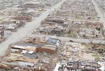
The Greensburg tornado family
The storm that would affect Greensburg (located approximately 110 miles west of Wichita) began forming after 5:00 pm CDT (2200 UTC) in the northeastern corner of the Texas Panhandle. It slowly intensified as it moved northeast through portions of Oklahoma, and then into Kansas. The first tornado warning with this cell was issued at 8:35 pm CDT (0135 UTC) for Clark County, Kansas. Several storm chasers captured the formation of a tornado southwest of Greensburg around 9:30 pm CDT (0230 UTC). The tornado apparently strengthened as it neared Greensburg, and at 9:38 pm CDT (0238 UTC), storm chasers reported that it had grown to over 1/2 mile (0.8 km) in diameter.
Several satellite tornadoes were observed as the monstrous wedge approached the town of Greensburg. At about this time the National Weather Service office in Dodge City issued a very rare Tornado emergency, which is the highest alert possible and is used only for extremely life-threatening situations when a large and likely violent tornado is on the ground and approaching a population center. The tornado plowed through the city shortly after it was intercepted by storm chasers. It was an estimated 1.7 miles (2.7 km) in diameter and was confirmed to have been an EF5 on the Enhanced Fujita Scale (the highest possible rating). Based on the damage produced, winds inside the tornado were estimated to have been in excess of 205 mph.
The town mayor would later state that 95% of his community was destroyed (and many houses were flattened or even blown away); Memorial Hospital sustained heavy damage (as many as 30 people may have initially been trapped inside). A motel on the west edge of town, two schools, a tractor supply company, the Greensburg City Hall and other businesses fell victim to the violent winds and were destroyed or flattened. The city's water tower was completely toppled and smashed. The Big Well which is the world's largest hand-dug well was also affected with the visitor's center being completely destroyed.
Train cars were also reported to be overturned and hazardous materials teams were called to inspect the wreckage. A tank car was carrying about 14,000 gallons (53,000 liters) of ammonia and the substance started to leak from the tank when workers were starting to lift back the tanker. The courthouse and the grain elevator were spared the worst of the tornado's effects. Meanwhile, the Greensburg meteorite, which was feared to have been blown away, was found and recovered a few days after. The tornado continued north before dissipating, and by several accounts continued to grow as it left town. The total path length was 22 miles (35.2 km), and the width of the funnel reached 1.7 miles (2.7 km).
After extensive surveys in the area, the National Weather Service office in Dodge City revealed that a second large tornado later developed just a few miles east of the Greensburg wedge. The new tornado rapidly grew to about 2 miles in diameter as it moved northeast. In Pratt County the tornado destroyed more homes, including one that was swept off its foundation. The tornado also affected several other communities, including Trousdale in Edwards County and Macksville in Stafford County. The same supercell spawned additional tornadoes that caused significant damage across Barton County where it affected the towns of Ellinwood and Claflin about two hours after the Greensburg tornado. Another tornado later hit the Holyrood area causing additional damage.
After additional surveys, NWS Dodge City had confirmed 12 tornado tracks by the Greensburg supercell in Kansas alone on May 4 including the two satellite tornadoes and an additional brief tornado east of Greensburg at 9:55 PM CDT at the same time the main tornado was weakening and dissipating a few minutes after at 10:05 PM CDT.
The Greensburg tornado was the first ever EF5 since the Enhanced Fujita Scale was implemented on February 1, 2007. Including when the older Fujita Scale existed, the last F5 to hit the United States was on May 3, 1999 during the Oklahoma Tornado Outbreak, when a tornado destroyed Bridge Creek.
The tornado event surpassed the number of fatalities registered on May 4, 2003 during the May 2003 Tornado Outbreak Sequence when 8 people were killed by three separate tornadoes that affected areas around Kansas City and points south and west of the city—the last major deadly outbreak registered in Kansas prior to the Greensburg event. It was also the deadliest day and single tornado to hit the state of Kansas since an F5 tornado (which was also the last F5 in that state before this event), hit Wichita and Andover in Sedgwick and Butler counties, killing 17 during the Andover, Kansas Tornado Outbreak on April 26, 1991. The Greensburg event was also the deadliest single tornado in the United States since a tornado hit Volusia County in central Florida on February 2, 2007 where 13 were killed in an EF3 tornado. It was also the deadliest day for tornadoes since 20 people were killed in six communities on March 1, 2007.
Aftermath
Hours after the tornado hit, the city was fully evacuated as it was judged unsafe. Some of the injured were transferred to hospitals in Dodge City and in Wichita. The Kansas National Guard was called in to assist in the security measures. Over 100 Red Cross officials were called in while some will work with the Federal Emergency Management Agency for the recovery efforts. Shelters have been established at the Haviland High School and Barclay College in nearby Haviland, Kansas and the Oddfellow Lodge in Macksville, Kansas. After the tornado, looting was reported in the community and at least seven suspects - including four soldiers that were not part of the relief effort and went to Greensburg on their own - were arrested and are facing charges of burglary and theft. A dusk-to-dawn curfew was put in place in the community after the tornado hit.
The American Red Cross is maintaining a registry of "Safe and Well" families at their website disastersafe.redcross.org. Meanwhile, official have also set a shelter for lost and injured animals as they reported to have found 163 animals alive in Greensburg after the tornado. Kansas Governor Kathleen Sebelius and President George W. Bush have both declared Kiowa County a disaster area.
Nontornadic events
Flooding
In addition to the tornadoes, widespread flooding occurred across central North America as a result of the same system producing continuous thunderstorms. There are two major reasons for the flooding. The first is that the storm system itself is moving very slowly, having produced significant tornado outbreaks in almost the same places for three days. The other reason is that the storms move along each others' path, so one storm drops heavy rain on the same place that the storm before it did (this is also known as "training").
In North Dakota, southern Manitoba and southern Saskatchewan, heavy rainfalls of 1-3 inches (25-75 mm) fell from this system from May 4 to May 7. Similar amounts were reported in Alberta on May 3 and May 4. Across portions of eastern Nebraska and western Iowa, rainfall amounts exceeded locally 6 inches of rain (150 mm) In northeastern and central Kansas, amounts approached 5 to 6 inches locally (125-150 mm).
Some of the worst flooding affected Topeka, Kansas, where several rescues had to be made, and the Kansas City Metro Area, where several roads were closed. In neighboring Missouri, levees broke along the Missouri River which caused extensive flooding to hundreds of homes and the northwest and central part of the state. The National Guard were assisting on filling sandbags to protect homes, schools and plants across the state which experienced some of the worst flooding since the Great Flood of 1993 which affected most of the Mississippi River Valley.
Torrential rains on May 10 had also caused flooding in parts of southern Missouri as well as in eastern Kansas. The heavy rains also affected activities surrounding the Riverfest (Wichita River Festival) which postponed some events until May 14. The Arkansas River reached record levels near Haven when it crest at 13.08 feet on May 8. Some flooding into low-lying areas was also observed in the Wichita Metropolitan Area. Rainfall amounts in southern and southeastern Kansas also exceeded 6 inches (150 mm) over a two-day period on May 6 and 7. There have been several reports of farmers who lost several cattles who have been tossed by the high water levels.
In Aberdeen, South Dakota, nearly 8 inches of rain (200 mm) fell during the weekend causing significant flooding in some areas around the city. It was also the city's new 24-hour record rain fell, breaking the older mark set in June 1978. The highest rainfall was reported in Epiphany, South Dakota where as much as 10 inches (250 mm) fell during the weekend.
In southern Oklahoma City and surrounding communities, strong straightline winds caused damage to several buildings and downed trees and power lines in the early morning hours of May 7, with cleanup efforts being complicated due to flooding rains accompanying the storm. About 11,000 homes were without power during the event. There were also reports of floods across many other areas in Oklahoma. Oklahoma Governor Brad Henry had declared a state of emergency for all 77 counties across the state due to all the severe weather including the tornadoes, the flash floods and hail.
Snowfall
Snow was also reported across higher elevations in Colorado, Wyoming, Nebraska and Utah with local amounts of up to one foot (30 cm) across central Colorado.