The Flood
The initial flooding began in June 1951 with heavy rains that month. The flooding reached its worst stages when between 8 and 16 inches fell on the region between July 9 and July 13. The flood levels reached their highest point since the Great Flood of 1844 and Flood of 1903. July 13 experienced the single greatest levels of flood and led to the greatest amount of destruction by flood experienced in the Midwest as of that date.
The actual flood-levels are not accurately known for the Kansas River, as the water crested above all official flood gauges. However, between Manhattan and Bonner Springs flood levels were between 4 and 6 feet (1.2 and 1.8 m) above all previous records. The Marais Des Cygnes River, Verdigris River, and Neosho River crested more than 9 feet (2.7 m) above previous records.
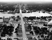
The heaviest initial damage by the flood crest was to Manhattan and Ft. Riley. Barracks at the Fort were destroyed and the downtown business district was deluged under 8 feet (2.4 m) of water. Following this, Topeka and Lawrence were also damaged by the same crest. Approximately 24,000 people were evacuated from Topeka.
The flood caused the Missouri River to change course at St. Joseph, Missouri cutting off the downtown area from Rosecrans Memorial Airport. In the aftermath the United States Army Corps of Engineers formalized the change by dredging its new channel. St. Joseph residents must now cross the Pony Express Bridge and go through Elwood, Kansas in order to reach the airport.
In Kansas City, the flood began running over the top of the levees protecting the Argentine and Armourdale areas, resulting in the evacuation of 15,000 people. Houses in Armourdale had water all the way to their roofs. The flood devastated the Kansas City Stockyards in the West Bottoms at the confluence of the Kansas and Missouri Rivers. The Stockyards would never fully recover. The flood destroyed the TWA overhaul base at Fairfax Airport in Kansas City, Kansas prompting the city of Kansas City, Missouri, to relocate TWA to a new airport in Platte County, Missouri that was to become Kansas City International Airport.
On July 13, a total of 1,074,000 acres (4346 km²) in Kansas and 926,000 acres (3750 km²) in Missouri were flooded. The crest continued downstream passing through Boonville, Missouri on July 17, Jefferson City, Missouri on July 18, Hermann, Missouri on July 19, and St. Charles, Missouri on July 20 resulting in further flooding.
Outcome
Following this flood a series of levees and reservoirs were constructed throughout eastern Kansas. This new network of flood control structures helped to prevent widespread damage when the region was hit later by the Great Flood of 1993. Prior to the flood there were five federal flood control dams in operation in the Kansas River basin:
Bonny dam in Colorado
Enders dam and Medicine Creek dam in Nebraska
Cedar Bluff dam and Kanopolis dam in Kansas
Several others had been planned by the Army Corp of Engineers and the Bureau of Reclamation, both authorized by the Flood Control Act of 1944.
Since then, many dams have been constructed so that a total of eighteen dams now control the flow of the Kansas River. Many other reservoirs and levees were built in nearby in other basins were also built as part of a response to this flood, such as in the Osage River basin above the Lake of the Ozarks.
Comparison to other big floods
Channeling and levee construction have altered how the floods have hit various areas along the Missouri River. Here's a comparison of the three big floods since the early 1800s.
Great Flood of 1844 - This was the biggest flood of the three in terms of rate of discharge at Westport Landing in Kansas City. It is estimated that 625,000 cubic feet per second (17,700 m³/s) was discharged in the flood. However the crest on July 16, 1844, almost a foot lower than the 1993 flood.
Great Flood of 1951 - The 1951 flood was the second biggest in terms of rate of discharge at 573,000 cubic feet per second (16,200 m³/s). The 1951 crest on July 14, 1951, was almost two feet (0.6 m) lower than the 1844 flood and three feet (1 m) lower than 1993. However, the flood was the most devastating of all modern floods for Kansas City since its levee system was not built to withstand it. It destroyed the city's stockyards and forced the building of an airport away from the Missouri River bottoms.
Great Flood of 1993 - The 1993 flood was the highest of any of the three but had the lowest discharge at 541,000 ft³/s (15,300 m³/s). While the 1993 flood had devastating impacts elsewhere, Kansas City survived it relatively well because of levees improvements after the 1951 flood.
|