|
|
|

|
|
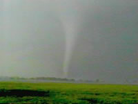
1991 Andover Tornado,
Andover, Kansas
|
|
|
|
|
|
|
The Andover, Kansas Tornado Outbreak was a violent outbreak of 58 tornadoes which took place on April 26, 1991, killing 24 people and injuring hundreds. The Andover outbreak was featured in Enemy Wind, a documentary produced by The Weather Channel.
|
|
|
|
The Andover Tornado
The tornado that produced the most extensive damage formed south of Clearwater, Kansas. It fluctuated between F2 and F3 intensity as it crossed I-35 and moved across the city of Haysville. Widespread damage was reported in Haysville, but there were no fatalities. On the east side of Haysville, the tornado became a solid F3 in strength as it crossed the Kansas Turnpike for the first time and headed toward McConnell Air Force Base.
Many people had advanced warning before the tornado struck McConnell Air Force Base. The tornado struck the base school & housing at F2-F3 strength. It caused $62 million in damage on base, narrowly missing a multi-billion dollar line of B-1 bombers. The damage path widened as the tornado intensified to F4 strength just East/Northeast of the base.
By 6:35 p.m., the tornado had expanded to just over 600 feet wide and was producing F5 damage on the Fujita scale. It continued to move Northeast toward the Golden Spur Mobile Home Park in Andover, KS; as it passed through, it obliterated the park and caused thirteen deaths. The tornado then veered north, missing Girl Scout Camp Seikooc, where summer camp training was being conducted as well as a troop campout.
The tornado then moved on to the Northeast, passing just south of Towanda, KS. Most of the damage in this area was rated at F2-F3 intensity, though these numbers may be skewed: the rural area's lack of significant structures makes it difficult to accurately gauge the amount of damage. The tornado continued Northeast and reached El Dorado Lake just before 7 P.M. Video taken by local storm chasers shows that the tornado crossed over the lake and revealed a multiple vortex structure. Just after crossing over the lake to the Northeast, the original circulations dissipated and a new, much weaker tornado formed. The Andover tornado had traveled for nearly 46 miles, and was on the ground for over an hour.
This was the last category 5 tornado that was recorded in Kansas under the old Fujita scale rating. The next tornado of that scale, an EF5, was reported 16 years later on May 4, 2007 in Greensburg in Kansas about 2 hours west of the path of the 1991 tornado. Since February 1, 2007, the National Weather Service uses the Enhanced Fujita Scale.
The El Dorado Lake Tornado
The new tornado moved Northeast toward Cassoday, KS. A news team from KSNW-TV in Wichita was returning to the station along the Kansas Turnpike from a story unrelated to the tornado. The reporters soon encountered a tornado, and decided to try to shoot video of the storm. However, the tornado veered and began following a path along the highway at a speed faster than they could drive. They reached an overpass where several people had already abandoned their cars. The cameraman advised the other people that they should all get into the very upper part of the overpass, thinking that this would shield them from the wind. The cameraman recorded the entire chain of events as the tornado passed nearby. The overpass itself did not receive a direct hit from the tornado, but it appeared to on camera. It lasted approximately 20 seconds. The tornado then continued northeast and dissipated at about 7:30 p.m., just Northeast of the Cassoday Interchange of the Kansas Turnpike. All the cars parked under the underpass had their windows blown out. Other cars and big rigs on the turnpike (actually hit by the tornado) rolled multiple times and were tossed all over the road.
The Red Rock Tornado
South of Wichita, in Garfield County, Oklahoma, tornado chasers (including Warren Faidley, Gene Moore, and many other big-name chasers) observed the touchdown of what would be the longest tracked tornado of the outbreak. Initially, the storm was narrow and produced up to F3 damage to the south of Billings. A few oil tanks were toppled and power poles were knocked down. As the funnel crossed into Noble County, video and photographic evidence suggests dramatic widening and strengthening. The damage path across northern Noble County appeared to be between 3/4 and 1 mile in diameter. Trees were debarked and pavement was scoured off roads. The tornado encountered few man-made structures along its path. At least one home was completely demolished leaving no walls standing (indicating F4 damage).
At one point a University of Oklahoma chase team used a portable dopplar radar to measure a windspeed of 257-268 mph in the funnel (near the F5 threshold). At the time, this was the fastest wind speed ever measured on the face of the earth (it has now been surpassed by the Moore, Oklahoma City tornado, which produced a 1/4 mile gust of 301 mph on May 3, 1999). As the tornado passed through Noble County and into Osage County, two farms were completely destroyed and several additional oil rigs were toppled. The tornado lifted in central Osage County, after having traveled for 66 miles. It is likely that this was the most violent tornado of the outbreak (exhibited dramatic multiple vorticies and motion); however, it did not encounter many man-made structures making it difficult for storm survey teams to rate it. It was given an F4 rating, which was probably the best they could have done, given the data available in the situation.
Aftermath
In addition to the millions of dollars of damage, 225 injuries and seventeen deaths, the tornado also contributed to the commonly held (albeit false) belief regarding tornado safety. Due to the popularity of the news team's video, in which they are depicted surviving by using an overpass for shelter, overpasses are now frequently jammed with people seeking shelter during tornado activity. Such was the case in many areas during the 1999 Oklahoma Tornado Outbreak, in which some people actually left the safety of their homes when the tornado warning was issued to take shelter under overpasses. One tornado hit three underpasses and killed people at each one.
An overpass is an extremely dangerous spot to be in a tornado, especially if it does not have the open girder design like that in the video. That bridge design is very rare; the vast majority of underpasses are mere open slabs, offering no protection from wind and debris. Using these underpasses as protection does little more than raise people above ground level, exposing them to higher winds and more debris. Additionally, the windspeed may be increased by the wind tunnel effect. Another danger is the sheer number of people now congregating at underpasses blocks traffic, which has hindered emergency responders. Moreover, it presents the danger that an intense tornado will hit people taking shelter as well as bystanders stuck in traffic, who are massed in a vulnerable location incurring the possibility of a significant death toll. NWS Presentation on Deaths Due to Use of Underpasses as Shelters
|
|
|
|
Many of these pages have used information from Wikipedia as their basis. Other information has been added by site owners as it is found and as time permits . We also invite users to submit info to be added to the site. |
|
|
|
|
|
Copyright Genuine Kansas 2007 |
|