Three quite large streams cross the county. The largest of these is the Marais des Cygnes River, which flows across the southern part, entering from the west, flowing across the corner of Barclay Township into Arvonia; thence east across that, Olivet and Melvern townships; thence northeast across Agency Township. The principal tributaries of the above named stream from the south are: Mud, Puleston, Winnifred, Coal, Long, Rock, and Tuqua creeks. On both the north and south sides are numerous other small creeks, but a short distance apart, which contain running water, for a portion of the year. Salt Creek flows across the county from west to east, through the central part and crosses the townships of Superior, Valley Brook and Agency, emptying into the Marais des Cygnes, near the eastern boundary. Mute Creek is its principal southern tributary. On the north side are Swede and Jersey creeks.
In the northern part of the county is Dragoon Creek, which entering from the west flows across the southwest corner of Burlingame Township; thence southeast across Dragoon, and across the northeast corner of Superior; thence nearly east across Fairfax, from whence it flows southeast across Junction and the corner of Agency, where it enters the Marais des Cygnes near the eastern limits of the county. Its principal tributaries on the south are Soldier and Smith creeks. On the north are Switzler, School, Pop Corn and One Hundred and Ten creeks. Besides these are Wakarusa, Berry's Slowbridge, Elk and Appanoose creeks. The above names streams are the principal ones in the county, though it is intersected by many small ones that contain running running water for a portion of the year.
Of the streams named above, the names are derived as follows: Marais des Cygnes means "the marsh of the swans." Dragoon is so named from the fact that a United States soldier died on its western bank, at an early date; Switzler from the name of a man who was run over and killed by a wagon, while descending the eastern bank, at a point on the old Santa Fe freight road. Salt Creek derives its name from a salt basin near its mouth. One Hundred and Ten Creek, from the fact that the old crossing of the Santa Fe freight road was that number of miles from Independence, Mo.; the Appanoose and Tauqua from those of two of the head-men of the Sac and Fox Indians. The Wakarusa is so named from a wild plant, partly covered with a fine hairy fibre, that once grew along its banks; Mute Creek was named from a deaf mute having held a claim on its banks at an early day.
Along the streams are low bottom lands, varying all the way from a few rods to three miles in width. Back from the valleys the surface of the land is undulating, and in some places much broken, and even bluffy. The 10 per cent of the county is low valley land, and 90 per cent upland; 10 per cent of the county is forest, and 90 per cent prairie. The average width of the bottom lands is nearly half a miles. The greater part of the upland is tillable, much of it very level and covered with well cultivated farms.
About 10 per cent of the county is covered by a natural growth of timber. This is found generally along the banks of the streams, in belts varying from twenty to upward of one hundred rods in width. The principal varieties are walnut, elm, oak, hackberry, cottonwood, coffee bean, mulberry and hickory. Besides these natural belts of timber, there are a large number of groves of forest trees, under cultivation on the farms, and which all told, comprise many acres.
Coal underlies the greater part of the area of the county, but it is not found in large quantities, or mined to any great extent, excepting in a belt comprising about 25 per cent of the county's area. This line follows along the line of the Atchison, Topeka & Santa Fe Railroad, and extends back for some distance on each side of it. It is found at a depth below the surface, of from two to more than one hundred feet, but at an average depth of from fifty to seventy. The veins are from twelve to thirty-six inches in thickness. The quality is good, the mines numerous, and the shipments are great. It is used extensively by the railroad companies, and for local, domestic and manufacturing purposes.
Limestone is found in all parts of the county. It is of an excellent quality for building purposes. A great number of the buildings of the county are constructed of this material. Besides this the stone is used to a great extent for fencing. Yellow ochre is found in abundance in every township. There is also an almost unlimited supply of fire and pottery clay, which is utilized to some extent.
Early History
The northern part of the county as far south as a line one-half mile north of the northern boundary of Township 16, comprised a part of the Shawnee Indian Reservation, which was opened to settlement by the act of Congress of May 30, 1854. Of this land a strip nine miles wide, and extending east and west, was a part of Shawnee County. South of this and extending across the entire county, was a narrow strip, which extended to the southern limits of Shawnee Reservation.
---
* For the early history of the county the writer is indebted largely to a history by the late Hon. James Rogers, of Burlingame, published some years since. In many places his own words are used.
---
The southern part of the county, from the above named line, comprised the greater part of the Sac and Fox Indian Reservation, which was a tract of land twenty miles north and south, and thirty miles east and west. Of this, a strip twenty-four miles east and west, and extending to its southern limits, together with the narrow strip lying between it and Shawnee County, was set apart by the legislature of 1855, and called Weller County, but all that was open to settlement was the narrow body of Shawnee lands.
The portion of Osage County then included in Shawnee was soon divided into two townships, called Burlingame and Wakarusa. These have since retained nearly their original boundaries, and the name of the latter is changed to Ridgeway. On February 11, 1859, by act of legislature, the name of Weller County was changed to Osage, an act for its organization being also passed. On February 23, 1850, the Legislature passed an act, attaching the nine mile strip formerly belonging to Shawnee, to Osage County, its present boundaries being then established.
In the year 1827, the United States Government opened a mail route from Independence, Mo., to Santa Fe, N. M., on the route that had been selected some time before by the freighters, and known as the Santa Fe Trail. This was the finest natural road in the world, and the immense freighting business over it continually increased, until by 1854, millions of dollars worth of freight was transported over it annually. This road entered the present Osage County from the east, about on the lines between Township 14 and 15, extended west, crossing One Hundred and Ten Creek, and continuing in nearly a direct line to where Burlingame now is, and up what is now Santa Fe Avenue in that town, and thence west crossing the western boundary of the county.
The Fort Leavenworth and Santa Fe Trail extended across the northwestern part of the county, and united with the main road some distance farther west. There was also a road from where Baldwin City now is, to the Sac and Fox Agency. Besides which there were many cross roads, and short cuts from different points, but the Santa Fe Trail was the terminus of them all.
When Kansas was formed as a territory, May 30, 1854, the only white settlers within the present limits of the county were two men living on One Hundred and Ten Creek, at the crossing of the Santa Fe Trail, and who had married Shawnees. Besides these, there were a few at the Sac and Fox Agency.
In 1844, the Sac and Fox Indians were removed from Iowa to their Kansas Reservation, the limits of which have been described. The first Indian Agency was established on the Marais des Cygnes River, at Greenwood, Franklin County. Sometime afterwards it was removed about eight miles further up the river to where Quenemo in Osage County, now is, the latter place being known as the new agency.
In 1854, there was a trading-post at the Agency owned by Baker & Street of Westport, Mo., but kept by a man named Case, who lived there with his family. The other white people there were Gen. Whistler, an ex-army officer, and Indian trader, and John Goodell. Both of these men had long before married into the tribe and were living with their Indian wives. Goodell's wife was Quenemo, from whom the town of that name derives its appellation. At that time the tribe numbered about fifteen hundred and with the exception of the chiefs and head men, lived in wigwam villages at different points on the reservation.
In 1858, the Government caused to be erected at the expense of the Indians, a large number of houses of wood and stone along the Marais des Cygnes and its tributaries. Saw-mills were erected at the old agency, and a large quantity of lumber was sawed. The contract for building the houses was let to R. S. Stevens, who received payment in Indian Scrip. They were rough and cheap buildings, with two rooms, a porch along one side, and were built in unhealthy places. It was with the greatest reluctance that the Indians paid for them, and then it required the greatest effort to get them to live there. They soon tore up the floors and broke out the windows. They drew, with charcoal, rough pictures on the walls, of steamboats, locomotives, and other objects of wonder they had seen in the east; and pictures of the various wild animals of the plains. They soon deserted the houses, declaring it made them sick to live in them, and again returned to their wigwams. By a treaty in October, 1859, the Indians ceded to the Government all the western part of their reservation, which was to be held in trust and sold for their benefit.
The land disposed of by the above treaty was opened for sale under sealed bids in 1860. A great many bids were made by residents of Kansas, but they were either overbid by parties in Washington, or else other lands of a poor quality on which they did not bid at all were awarded them. The best of the land was bought by Hugh McCullough, Secretary of the Treasury; John P. Usher, Secretary of the Interior; and Wm. P. Dole, Commissioner of Indian Affairs. The greater part of the remaining lands were awarded to Perry Fuller, R. S. Stevens, and John McManus, who were holders of large amounts of Indian scrip, which they used in payment at its par value.
Although contrary to the wishes of the tribe, in 1867, a treaty was made with its chiefs and head men, by which they were to give up the remainder of their reservation to the United States Government. In October, 1868, the treaty was ratified by the President, and in due time the Indians were removed to Indian Territory. They then numbered 800. The best of the lands were given away to the chiefs and Indian head men, and to a few white men who had been instrumental in securing the treaty. The remainder were opened to actual settled and sold for $1.50 per acres.
The first settler to locate within the limits of the county after May 30, 1854, was John Frele, who came with his family soon after that date and stopped at the point on the Santa Fe trail where Burlingame now is. They only person living anywhere in the neighborhood was a Shawnee Indian who had a cabin, by a spring, in what is now the northern part of the above named town. Frele bought this claim, and moved into the cabin. The next winter a son was born to Mrs. Frele. This was the first white child born in the county.
Before August 1, 1854, I. B. Titus, James and John Aiken, Alphonso Prentis, and a few others took claims on Switzler Creek. John Skidmore, Wm. Aiken, John Ward, Hollam Rice, Samuel Devaney and Henry Harvey, with his sons George and Samuel, located on Dragoon Creek.
One August 2, Fry P. and Mobillon McGee arrived at One Hundred and Ten Creek, and bought out the claims of two white men then living there. On the same date Moran McGee and C. M. Linkenauger selected claims near the mouth of Switzler Creek. Of the settlers up to this time all were pro-slavery men except Harvey and his two sons, who were Quakers.
In September, 1854, the American Settlement Company was formed in New York City, and offices were opened on Broadway. The project of the company was to locate a town-site somewhere in Kansas and to build up a large city. The proposed town was to be named Council City, and was to be laid out with streets one hundred and fifty feet wide, along which trees were to be planted, and a park of eighty acres to be laid off. A committee, consisting of Loton Smith, George M. Barnes and J. W. Kerr was appointed to visit Kansas and select a location. Starting at once, they prospected in various parts of the territory, and selected a site just east of Switzler Creek and adjoining the present Burlingame.
In the fall of 1854, quite a large party started out from the western counties of Pennsylvania to settle in a colony somewhere in Kansas. Most of them were from Mercer, Bradford and Indiana counties. Prominent among them were George Bratton, Absalom W. Hoover, J. R. Stewart, Marcus J. Rose and Thomas Black. On the arrival of the Pennsylvanians at Kansas City, they fell in with another party from New York and other Eastern States, who were waiting for the return of the Council City locating committee. Early in November, the committee having returned, the entire party, numbering about one hundred, started out. On the 9th they encountered a severe snow storm, but they pressed on, and on the 14th arrived at their destination.
Soon after their arrival a number of the party selected claims as near the proposed town-site as possible, but the greater number of them, who had been clerks, or engaged in occupations that unfitted them for hard labor, and who had come with the expectation of gaining untold wealth without work, were so discouraged that they started back within twenty-four hours. Of those who located claims only fourteen remained during the winter, as cold weather was fast approaching and they had no places to live and but few tools to work with. George Bratton, Absalom W. Hoover and some others were accompanied by their families, and they built cabins or dug caves at once, and there they lived quite pleasantly during the winter. The weather was mild and there was little suffering. Early in the spring nearly all who had located claims the fall before returned, and all went to work making improvements on their farms.
The first election was held on March 30, 1855, for the purpose of electing a delegate to the first Territorial legislature. Gov. Reeder named Council City as the voting place. On the day previous to the election, a large body of Missourians, armed with rifles and having a large quantity of whisky arrived at Council City, and camped in the woods just north of Titus' cabin. They spent the night in drinking whisky, yelling, cursing the Free-State cause and firing their guns.
On the morning of March 30, the regularly appointed Election Board met at the unfinished log cabin of I. B. Titus, about fifty yards south of the bridge that now crosses Switzler Creek east of Burlingame. No sooner were the polls declared open than the Missourians appeared on the scene, tore a window out of the cabin, drove away the judges, and appointing others of their own number, took possession of the polls, and drove the few Free-State men away. They spent the day in drinking, swaggering about, with threats of violence toward the Council City people; all voted, and some of them several times. At night they closed the polls and moved back as far as One Hundred and Ten Creek, where they camped, continued their drunken orgies and went through the form of counting the votes, declaring Mobillon McGee to be elected by an unanimous vote (about 250). Though he had located a claim the fall before, McGee was then a resident of Westport, Mo. The next morning the ruffians resumed their march to Missouri
Gov. Reeder was then at Muncie, and was at once apprised of the violent measures used at Council City, when he ordered a new election, at which Hollam Rice was elected, receiving twenty-eight votes, every one in the district. Gov. Reeder issued a certificate of election to Rice, but upon meeting the legislature excluded him and admitted McGee.
Ridgeway, then called Wakarusa, had been settled some time before. The first settlers were Allen Pierson, and his two sons, John and Elias. Soon afterward O. H. Bronson, a Pro-slavery man, located there. The March election was conducted about the same as at Council City, and Bronson declared elected to the legislature.
In the spring of 1855 there was quite a large immigration, the greater number locating around Council City. A large block house called the council house was erected. A portion of it now stands in the western part of Burlingame. The town site of Council City was surveyed and staked into lots, and comprised all the territory between Dragoon and Switzler, for three miles above the junction.
The following were among the early settlers in the county: Phillip C. Schuyler came in the spring of 1855, and purchased a claim comprising what is now a large portion of the city of Burlingame. Samuel R. Caniff came with Schuyler, and purchased the claim of John Frele, and moved thereon at once. This is now a part of Burlingame. Abel Polley, Wm. Tillinghast, Abram Leonard and E. O. Perin selected claims on Dragoon Creek, the last two named erecting cabins at what was afterward Superior. John Drew settled northwest of Burlingame, and David Hoover northeast. Henry and John Smith, A. R. Bothel and Ithiel Streit located on Soldier Creek; Wm. Lord, A. N. Havens and Armi Smith on Plumb Creek, J. G. and Henry Morrell, and Victor McDonald bought out claims on Switzler Creek, and Lucien, William, Charles and Edmund Fish located two miles further east.
Among other early settlers, J. Q. Cowee, B. V. Beckus, J. B. Sanders, John R. Stagg, Caleb Beckus, Orlo and M. C. Drinkwater, James Brownlee, T. J. Bass and T. Clelland settled in the Wakarusa Valley. They were all earnest Free-State men. Jonathan West settled still further east, near the north line of the county. In what is now Ridgeway Township, prominent among the first settlers were Wm. Atchison, Geo. Roberts, H. H. Heberling, Robert and Morris Clark, Joseph Law, and Phillip T. Huff, the last of whom was the first Justice of the Peace for that township. Of the first settlers on One Hundred and Ten Creek were Wm. D. Harris, formerly an Indian trader and postmaster on the Santa Fe trail, Geo. J. Johnson, Henry and Charles Rubo, James T. Shepard, John Rehrig, L. M. Wyatt and D. B. Burdick. In the extreme southern part of Ridgeway Township were T. M. Gilmore, John H. Hook, Robert Watts, James and John Coleman, Frank, Peter and James Duffey. Between Burlingame and One Hundred and Ten Creek were E. S. Borland and Michael Supple. In the eastern part of the county were Peter Paulson, and John and Peter Peterson.
The first regular religious services in the county were in 1855, at the Council City settlement. Rev. John Lowry was the minister. He was sent out by American Missionary Society, and for three months meetings were held regularly at the cabins of the settlers. Sometimes at one place and sometimes at another. The attendance was always good, although almost the only mode of conveyance was by ox-teams.
When the town of Council City was projected Loton Smith was sent out as resident agent, but sometime in 1855 he was succeeded by James M. Winchel, who located in the spring of that year.
On March 29, 1855, Albert Cornelius, son of Mr. and Mrs. Ithiel Streit was born. This was the second birth in the county. The first female child born in the county was Miss Emma Bratton, on June 29, 1855. She is the daughter of Rev. and Mrs. George Bratton, and is now living at Burlingame, the wife of Samuel Shibley. The first store in the county was opened at Council City in the spring of 1855, in a log cabin just north of the spring, across the ravine. It was kept by Samuel Allison.
The first post-office was established on April 30, 1855, and called Council City. Loton Smith was appointed postmaster, but did not serve personally. James Bothel was deputy postmaster, and did most of the business. The post-office was kept at Allison's store. In the fall of 1855 James Bothel and Joseph McDonald bought Allison's store, and for several years were the leading merchants of the county.
Up to the fall of 1855 several deaths had taken place, and cemetery grounds were selected about one mile west from the post-office. But as it was afterward found to be on a school section, the site was abandoned and the present cemetery grounds selected. The first Fourth of July celebration was in 1855, at the place where the county poor farm now is. About seventy-five persons were present, and speeches were made by P. C. Schuyler, Loton Smith, and J. M. Winchell.
The first marriage recorded in Osage County is that of John Riffenbark to Hannah Thompson, January 23, 1860. M. Rambo, as Justice of the Peace, performed the ceremony. The first school was taught by Miss Louisa Todd, the daughter of Henry Todd, in a tent adjoining the council house. This was in the spring of 1855. The school was supported by subscription, the greater part being paid by bachelors.
The first settlements were made before there were any surveys, and each settler selected as nearly 240 acres as possible. They then banded together to protect each other in possession of the claims. It was afterward found that only 160 acres were allowed to a settler, and when surveyed the section lines cut the original claims into irregular fragments, and on making final proof each settler was required to make oath that he had not agreed to convey any portion of his claim to any one else. All this created general confusion, and many were the quarrels and law suits that resulted.
In the spring of 1856, the Council City town site was abandoned, and J. M. Winchell and several associates laid out a town two miles south from Burlingame, which they named Fremont. A saw-mill was at once erected on Dragoon Creek, near the mouth of Switzler. Its sawing capacity was only two hundred feet per day, and the boards were from one-half inch to one and one-half inches in thickness. Not proving a success, this mill was soon moved away.
In May, 1856, Schuyler & Caniff brought in a large steam saw-mill, and erected it near the center of the proposed town of Burlingame. A large business was soon done. The old council house was occupied as a hotel, and its very moderate accommodations were severely taxed by the influx of travelers.
During the summer of 1856 nearly every one in the settlement was sick with malarial disease, and there was no skillful physician in the neighborhood. Loton Smith and many others died from want of care and medical attendance. The people were also badly in want of necessary provisions and were compelled to live on melons, squashes, pumpkins and green corn, or starve. As soon as the corn became hard enough to be grated, holes were punched in the bottoms of tin pans, and it was grated from the cob. Previous to that time Absalom W. Hoover had made a hand-mill of lime-stones (sic). After the corn became ripe and hard this mill was kept running constantly. Settlers came from many miles to grind their corn here.
In 1857 the Burlingame town site was surveyed, and named in honor of Anson Burlingame, afterwards United States Minister to China. The Burlingame Town Company was incorporated in February, 1858. About the same time the name of Carbondale was changed to Superior, and a Town Company incorporated. It was composed of J. M. Winchell with several associates from Wyandotte, who united with him and put forward strong efforts to build up the town. For some time there was strong rivalry between the two towns, and at one time it looked as if Superior would soon crush its rival. A road was opened through it from Centropolis to Allen, Dragoon Creek bridged, shops built, stores opened, and about thirty dwellings erected. Among the buildings, the Superior hotel was a very large one, and was afterwards used as hotel, court house, schoolhouse and church. That is the only building now left, and is occupied as a barn and granary.
There was another town projected in 1857, east of Switzler Creek, and called Arvilla. A store and two dwellings were erected, but finding difficulty in obtaining water, the new town was soon abandoned.
J. M. Winchell, Rev. Alonzo Shurtleff, and Prof. Daniels, then State Geologist of Wisconsin, formed themselves into a Town Company, and laid out a new town on the old Fremont site, which they called Carbondale. A steam saw and grist-mill was erected, and a Presbyterian Church organized, with Rev. James Brownlee, pastor, and preaching was held in a log-cabin.
Prairie City was the name of another town site on the Santa Fe trail. Its location was on Section 6, Township 15, Range 15 east. The first settlements began in October, 1856. The Town Company was formed in Kentucky. Dr. Robert Lester was one of its officers. The other early settlers were James Gilchrist, James Gilchrist, Jr., P. L. Doane, Joseph Bridgewalder, and John M. Carr. Mr. Lester was soon killed accidentally, and the town site was abandoned.
Young America was the name of a town projected on One Hundred and Ten Creek. The Town Company numbered fifty-three members. Among them were Hon. D. B. Burdick and Dr. Anderson. The place never succeeded in becoming a town.
Eureka was the name of a town projected by the Pennsylvania Colony in the fall of 1854. The site just east of Switzler Creek was soon abandoned, the settlers becoming interested in the Council City movement.
In 1858, another town called Havana was laid out, about four miles west of Burlingame. For a time it looked as if it would become the great town of the neighborhood. The City Company was made up of wealthy Germans of Chicago and St. Louis. About fifty German and French families located in the vicinity, large farms were opened, and in the town a store with a large stock of goods was opened, the machinery for a large mill was brought on, about half-a-dozen dwellings, and a large stone hotel erected. A large stone distillery and brewery was commenced. But its prosperity soon came to an end. The leading merchant failed, the members of the company quarreled, the settlers soon became dissatisfied with a country life, and it was not long until all left never to return, and the town became extinct. The hotel is now a barn, and the distillery became Davis' grist-mill.
A town was projected just west of the point where the Santa Fe trail crossed One Hundred and Ten Creek. It was called Versailles, and the Town Company was incorporated on February 20, 1857, with Henry P. Throop, D. T. Mitchell, and J. C. Thompson, as its members. For a time considerable business was done, and a large hotel built, but it never assumed the proportions of a town and has long since ceased to exist. The site was Section 2, Township 15, Range 15.
Previous to the Versailles town site, Fry P. McGee and W. D. Harris entered a town site at the Santa Fe trail crossing of One Hundred and Ten Creek, and names it Washington. No attempt was made to build up a town, however, though it became quite an important trading point.
Indiana City was laid out on a neighboring section, and a town site entered. Four small houses were framed, all ready to put up, in Louisville, Ky, and shipped out and erected. The town never became any larger. This was a portion of the present Scranton town site.
In Ridgeway Township was the site of two proposed towns, to be called respectively Georgetown and Ridgeway. Neither of them grew to be towns of any importance, though the latter is now a station on the Lawrence & Southwestern Railroad, and has a store, post-office, blacksmith shop, and a number of houses. A Masonic Lodge was organized in 1874, with the following charter members. C. M. McDivitt, Geo. W. Watson, C. H. Easton, J. S. Riley, H. K. Riley, Geo. R. Emory, J. B. Emory, J. S. Barbour and Joseph Law.
Political and Other Troubles
In 1855, the first Free-State elections were held, and here too, some political frauds were committed, as at a caucus held by them, more ballots were cast than there were voters present. A Free-State legislature at Topeka was elected, and from the Council City district, Henry Todd and Wm. Toothman were elected members of the Lower House; and Lucien Fish of the Senate. Early the next year, this legislature met and elected Philip C. Schuyler Secretary of State, but as the United States Congress did not recognize its legality, he never fulfilled the duties of the office.
The first military company was organized in 1855, and was called the "Old Free-State Guards." Henry Todd was Captain; Wm. Toothman, First Lieutenant; G. I. Drew, Second Lieutenant, and L. D. Joy, Orderly Sergeant. It was about the close of the year when the organization of the company was completed, after which it marched to the defense of Lawrence at once. Gen. Lane, Pomeroy, John Brown, Schuyler and Winchell were already there and manifested great joy at the appearance of the company. Each of its members was armed with a six-shooter rifle. These guns proved to be utterly worthless, and Loton Smith took them to Missouri, where he represented himself to be a friend to the Pro-slavery party, and sold them for a high price, and with the proceeds bought good rifles for the company.
During the year 1856, the troubles between the Free-State men and the border ruffians assumed a serious aspect. In June another military company was organized by the free-soilers. A portion of Buford's Company from the Southern States was sent to drive the Free-State men from the country. They camped on One Hundred and Ten Creek, where they remained all summer, made several raids on the Free-State settlers and committed many outrages. Joseph McDonald was robbed of a wagon-load of provisions, on the Santa Fe trail, while en route from Westport. As he was a cripple and a non-resistant his life was spared. He then went to Leavenworth for another load, and narrowly escaped being robbed again.
Horace L. Jones, who lived at Council City, had succeeded in getting possession of three hundred dollars of the New York Tribune fund, raised for the benefit of the destitute of Kansas. He refused to give it up or expend it for the sick, but sent a man with his team to Leavenworth, to purchase a load of flour and groceries, with which to start a store. On his way back the load and team were captured by the border ruffians, who sent the man down the river on a raft. Jones was considered one of the leading men of the settlement, and was known throughout the Territory as "Buffalo" Jones. Two or three years afterwards he left Osage County.
From June until December, it was impossible to get provisions from the Missouri River, unless the wagons were protected by an armed guard. Many depredations were committed on Free-State settlers. On the 4th of July nearly every man in the settlement went to Topeka to celebrate and to prevent the border ruffians from making an attack on the Free-State Legislature, which was to convene on that day. They were dispersed at the point of the bayonet, by a body of soldiers under Col. Sumner, and immediately returned home. A short time after, a plan was laid by Buford's men to burn and rob the entire settlement, which was prevented only by the timely warning of Fry P. McGee a Pro-slavery man.
In 1857, immigration to the county increased, and soon the Free-State men had a very large majority. During this year political affairs moved on more smoothly. The laws passed by the "bogus legislature" of 1855, were not generally respected. During the summer a Deputy United States Marshal appeared for the purpose of collecting a poll tax of one dollar, imposed on each voter, by the Pro-slavery Legislature. He was resisted, and after being shot at a few times, he disappeared, never to return. Some time during the fall, a party of Free-State men came in from a distance, and began committing outrages on Pro-slavery men.
Fry P. McGee, John Ward and Charles Skidmore were robbed of nearly all their personal property. The Free-State people of the neighborhood, however, followed them up, and compelled them to give up a portion of their plunder. At an election in the fall, Lucien Fish was chosen as a member of the Legislature. At a Free-State convention, P. C. Schuyler was nominated for Secretary of State, and with the rest of the ticket was elected, under the Lecompton Constitution. In January, 1858, an election was held on the Lecompton Constitution. Only three votes were cast for it in what is now Osage County.
In February, 1858, the bogus laws were repealed, and the next month Justices of the Peace were elected for a term of two years. For Burlingame, Wm. Lord and John Drew were elected. The township had been formed on September 21, 1857, and the October election was held at a building opposite the Burlingame Hotel. The judges of election were Thos. Russell, Wm. Lord and C. D. Marple.
In 1859, a terrible storm of wind and rain swept over the county, which resulted in great loss of property. Many persons were badly injured, but no lives were lost. In Burlingame several buildings were blown down, while at Superior nearly every building was completely demolished.
In August, 1859, the land sales took place in this district. The settlers were generally poor, and without money to pay for their claims. Nearly all had to borrow money, and some disposed of their land at once; in many instances getting but a small portion of its real value. The usual rate of interest was 5 per cent per month, and this with the principal was secured by a mortgage upon their lands. The greater number of those who remained afterward lost their land, it being sold under mortgage, as it was impossible to pay such a rate of interest, much of which had to be compounded every year. There was a poor market for crops, and the savings of the settler were very small.
The great drought of 1860, which extended throughout Kansas, was particularly severe in Osage County. From June, 1859, to November, 1860, there was no rain to afford any nourishment to vegetation. Everything dried up, and there was no crop of any kind raised. The settlers were soon reduced to a suffering condition, and many left the country. Those who remained were only saved from starvation through aid in the form of provisions and clothing sent by the people of more Eastern States. Aid societies were formed, and through them the most of the goods sent in were disbursed. In Osage County, S. R. Caniff, of Burlingame, and O. H. Sheldon, of Superior, were appointed to distribute aid and goods to the needy. Outside contributions were liberal and all were kept from severe suffering, though many privations were endured.
On January 11, 1861, one of the most severe snow storms ever known in the history of the country began. Considerable suffering was endured, but no lives were lost. On a level the snow would measure more than twenty inches in depth, and it drifted so badly that travel was suspended for nearly three weeks. It remained on the ground for twenty-four days, when it disappeared as suddenly as it came, and the streams were filled to overflowing. This was the first wet period for more than a year. Notwithstanding the big storm and the drought of the year before, the stock were in good order in the spring.
The first grasshopper raid was in 1866. On the 15th day of September they appeared in clouds, and beginning to descend it was not long until every green thing was eaten, and all growing crops, completely destroyed. Not only this, but they deposited their eggs by the countless millions. But a small percentage of these hatched out, yet the next spring there were enough to seriously injure the wheat crop. The young corn was damaged, but before June they had flown away, which gave sufficient time to replant corn, wherever it was necessary, and taken all in all good crops were raised.
In the summer of 1874, the grasshoppers again appeared in myriads. It was just at the close of the small grain harvest and little damage was done except to corn and gardens. Late crops of all kinds were utterly destroyed. But little corn was raised. During the following winter times were very hard, and many citizens were compelled to accept aid sent in from Eastern States. Eggs were again deposited, which hatched out in the spring, and the fields of growing grain swarmed with young grasshoppers. The small grain crop was somewhat injured, but the corn crop was good, as the pests had left the country by June 1. Still suffering from the partial failure of the year before, there were probably more privations endured until the crop of 1876 could be gathered, than at any other time since the very early years of the settlement of the country.
County Organization and Elections
During the earlier years of settlement, the citizens of the northern part of Weller County voted at Burlingame, and no objection was made until Superior became a rival town. Being refused a chance to vote, though containing only about thirty voters, Weller County took steps to secure an organization, an act for that purpose being passed by the legislature February 11, 1859, and the name changed to Osage. A commission composed of A. Leonard, A. H. Shurtleff and T. R. Merritt, was appointed to select judges of an election, which was to take place the fourth Monday in March.
The first meeting of the County Commissioners was held April 27, 1859, at Superior. The Board was as follows: V. R. Morrill, M. Rambo, and A. T. Dutton. E. M. Perrin was Clerk, and John Rambo, Deputy. At an election on June 7, J. L. Rooks was elected Judge; D. B. Burdick, Sheriff; and J. Perrill, surveyor. The first regular election was November 8, 1859, and resulted as follows: J. R. Carrier, Superintendent of Schools; M. Rambo, Judge; C. C. Crumb, Sheriff; A. N. Hulburd, Register of Deeds; W. O. Fisher, Attorney; John Rambo, Clerk; A. T. Dutton, Treasurer; J. P. Perrill, Surveyor; and A. Leonard, Coroner.
On June 7, 1859, delegates to the Wyandotte Constitutional Convention were elected. In Osage County, James M. Winchell was chosen from Superior, and Hiram D. Prescott from Burlingame. At the meeting of the convention, Winchell was chosen its President by a unanimous vote, and by his great ability, gained the respect of the entire body. He was afterward a prominent candidate for the United States Senate. Before coming to Kansas he was a school teacher. He was visionary, but bold and energetic, and always exerted a great influence on his associates. He was an inveterate enemy of Gen. J. H. Lane, and lost no chance to make his feelings known. After the war began, he became Washington correspondent of the New York Times, and soon became reconciled to Lane, after which they were warm friends. He speculated in gold and became rich, but afterward lost all, and retired to Westchester County, New York, where he died a few years since.
In the fall of 1859, a legislature was elected under the Wyandotte Constitution; O. H. Sheldon, H. H. Heberling and S. R. Caniff were chosen as members from what is now Osage County. On February 23, 1860, an act passed the legislature, cutting off the southern part of Shawnee County, and adding it to Osage, making the dividing line between Townships 13 and 14, where it has since remained unchanged.
On February 27, 1860, another act passed the legislature, perfecting the organization of Osage County, and ordering the Register and Clerk to at once take possession of all records relating to Osage under its new boundaries. At the same time, Philip C. Schuyler, James M. Winchell and O. H. Sheldon were appointed commissioners to locate a permanent county-seat, and then to call an election for the approval of the voters, and also to make arrangements for the erection of public buildings. Should the citizens of the county not approve of the county-seat first established, another place was to be chosen, and another election called. The southern boundary of Osage County was also defined as it now exists, and a special election for the choice of county officers was appointed. The commissioners appointed, located the county-seat at a point about midway between Superior and Burlingame, and named it Prescott.
On March 17, the county was divided into three commissioners' districts, and an election of officers appointed to take place on March 26. At that election J. L. Rooks, John Dodge and George Hall were chosen Commissioners; S. A. Fairchild, Judge; N. G. Densmore, Clerk; L. R. Adams, Register of Deeds; James Stewart, Attorney; D. D. Rooks, Sheriff; George Roberts, Coroner; C. C. Crumb, Treasurer; H. D. Preston, Surveyor; John Perrill, Assessor; and James Brownlee, Superintendent of Schools.
The county-seat election was held April 24, and Prescott rejected; therefore the seat of justice was held at Superior, a portion of the hotel being used as the court house. The first term of district court for Osage County was held on October 14, 1861, at Superior. R. M. Ruggles was presiding Judge; E. S. Borland, Sheriff, and A. L. Hulburd, Clerk. Previous to the above date, the county was attached to Shawnee for judicial purposes.
In the fall of 1861, and also in 1862, James Regers was elected to the legislature from Osage County, over his competitor P. C. Schuyler, beating him by six votes the first year, and by only one vote the next time. They were warm friends, both free-soil Democrats, and ran only on their personal popularity.
The Legislature, early in 1861, made provision for another county-seat election. The contest was between several points, neither gaining a victory. Burlingame received the highest number of votes. On January 24, 1862, the first meeting of the County Commissioners was held at that place. Another election was held in April, with the following results: Burlingame, 138 votes; Versailles, 74 votes; and Havana 1 vote. This gave the county-seat to the first named town, where it remained for many years.
County Seat Contest
Burlingame, the county-seat, being located so far from the center of the county, as soon as the Indian reservation was settled, a movement was made to change its location. An election was held October 18, 1870, which resulted as follows: Lyndon, 1,145; Burlingame, 997; and Keithville, 2 votes. The county-seat was declared at the first named place by the Board of Commissioners. The Burlingame people, however, got out an injunction preventing the removal of the county offices and records. Thus began a series of county-seat elections which engendered much bitterness between different sections of the county, which, at times, threatened to seriously retard its progress.
On August 6, 1872, another election was held with the following result; Burlingame, 954; Osage City, 456, and Lyndon, 1,042 votes. Neither place receiving a majority of all the votes cast, another election was held on August 20 between the two places receiving the highest number of votes. That election gave Burlingame, 1,407 and Lyndon 1,175 votes, and the former was decided to be the county-seat. In response to a petition, another election was ordered to take place on May 25, 1875. Burlingame despairing of retaining the county-seat, secured the laying out of a town on Section 34, Township 15, Range 15 east, near the center of the county, which was called Shireton. At the election Lyndon received 888, Osage City, 791, and Shireton, 785 votes. Neither place receiving a majority of all the votes cast another election was called between the two points receiving the highest number of votes, to take place June 8. Lyndon received 1,131, Osage City, 1,049, and Shireton, 288 votes. As only the two first-named points were considered to be legally in the contest, Lyndon claimed the county-seat.
On the other hand as that town did not receive a majority of all the votes case, Burlingame secured an injunction against the removal of the county records. Pending the decision of the courts, the Sheriff and Treasurer moved their offices to Lyndon, some time in the fall of the year, but were compelled to move back to Burlingame by a mandamus. Upon a decision of the district court in favor of Lyndon, that town again tried to get the records, but another injunction was served, and the case was carried up to the Supreme Court by the Burlingame people. The Lyndon people then determined to get possession by force, and a small body of men was formed, and teams sent to bring away the records, but the citizens of Burlingame, learning that they were coming, formed themselves into an armed bank and took possession of the court house. They also sent out men, one or two at a time, to reconnoiter, but they were all captured by the Burlingame scouts and confined in the jail. Thus ended the first attempt.
The Lyndon people then returned home and soon collected a force of about 400 men, from the southern part of the county, who were armed with all kinds of weapons. This enraged body of men marched upon Burlingame, determined to secure the county records or burn the town. Scouts were sent in advance to investigate, and they found the court house filled with armed men, intent on defending it and retaining the records. There was for a time danger of a battle, both sides having been worked up to crazy fury. At last the cooler among the leaders of each side met and offected (sic) a compromise, Burlingame consenting to give up the records, believing this the only way to save the town from being burned.
The first meeting of the County Commissioners at Lyndon was on November 16, 1875. The Supreme Court afterward affirmed the decision of the court below, and the county-seat remained at Lyndon.
But still the vexed question was not regarded as settled, and in response to a petition another election was called to take place March 12, 1878. Lyndon, Osage City and Burlingame were the contesting points. The contest was a bitter one, each town putting forth every effort to secure a victory, and on the day of election great frauds were committed in all parts of the county, but more particularly in the towns mentioned, each of which polled more than twice the number of votes that there were of voters in the township. As a result Lyndon receive 1,745, Osage City 5,204, and Burlingame 2,003 votes. This was more than double the number of legal voters in the county. On this election Osage City claimed to be the county-seat, and at first attempted to secure the removal of the county records, but the election frauds were so plain that the courts refused to have anything to do with it, and the matter was finally dropped.
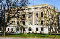
Since the above named election, the county-seat has remained at Lyndon, and though the people have not yet voted to build county buildings, the question is generally regarded as settled. When the county-seat was at Burlingame, a court house was built there by subscription by the citizens. At Lyndon no court house has been built, and the county officials occupy rooms in different parts of the town, leased by the county. There is a jail at Lyndon, and a substantial poor house, on the poor farm, not far from Burlingame.
The present county officials are: John C. Rankin, Treasurer; C. A. Cottrell, County Clerk; H. W. Jenness, Register of Deeds; J. D. McCabe, Surveyor; Alexander Blake, Probate Judge; R. C. Heiser, County Attorney; A. Cotterman, Clerk of Court; Harry Smith, Sheriff; Calvin Ransom, Coroner; Commissioners, First District, George S. Brock; Second District, H. M. Crum; Third District, A. I. Lanning; H. K. McConnell, Superintendent of Schools; Max. Buek, Representative, Forty-fourth District; W. C. Sweezy, Representative, Forty-fifth District.
War Record
On the breaking out of the civil war in April, 1861, the citizens of Osage County made arrangements to do what they could to serve their country, and on the 14th of the following May the following men enlisted in the Second Regiment, Kansas Volunteer Infantry:-Robert H. Baird, Samuel Houston, James R. Stewart, Orlando P. Rooks, Reuben F. Playford, William C. Chatfield, Norman Curtis, J. R. Drew, William Y. Drew, Thomas W. Rogers, H. A. Dutton, Silas M. Hills, John Hendry, Howard Schuyler, Charles W. Ryus, Frederick Schuyler, N. T. B. Schuyler, Julius D. Wright, John Rambo, A. W. Boyce, A. W. Baily, Robert A. Bratton, Charles H. Gooder, F. G. Hunter, Abraham Leonard, Fernando Olds and S. T. Shunk. After a campaign in Missouri the regiment was discharged on October 31.
During the war Osage County furnished more than its quota of volunteer soldiers, many of whom particularly distinguished themselves for bravery. No companies did more effective duty than did those from Osage. A great number served in the Eleventh Kansas Regiment. A great many left Osage County to join regiments from other States. Among them were A. U. Perrill and A. A. Hederstrom.
At the time of Price's raid, Gen. Curtis and Gov. Carney called out the Kansas State Militia, and nearly every able-bodied man in Osage County went out. The campaign lasted three weeks, when upon the retreat of Price, the men returned home. The militia from this county composed the Santa Fe Road Battalion, which was commanded by Col. M. M. Murdock.
Among prominent and brave men of the county who were killed or died during the war were: Dr. S. A. Fairchild who was killed by guerrillas while attending their own sick, E. P. Sheldon, S. F. Shunk, Thomas W. Rogers, Merritt W. Young, William West, Isaac F. Thiers, Joseph E. Cole, John and William Eckenkamp, Madison T. Hughes, Joseph H. Marple, Capt. Silas H. Marple, John C. Rooks, Augustine C. Rosencrantz, Henry Boyle, Capt. D. D. Rooks, George W. McDonald, John Collins, Horace, Loring and Edwin Dutton.
Railroads, Schools, Etc.
At the close of the war with the increased prosperity of the country, movements were soon made to secure a railroad. In September, 1865, bonds were voted to the Lawrence & Emporia Railroad and to the Atchison, Topeka & Santa Fe Railroad. The first named road was never built. To the latter, $100,000 additional bonds were voted in June, 1867, making $150,000 in all. The road was built in 1869, and the bonds issued in September of that year.
In November, 1870, bonds were voted to the Lawrence & Carbondale Railroad, to the amount of $50,000, to which Ridgeway Township in 1872, added $25,000, and the road was completed in due time. For several years succeeding 1870, many lines of railroads across various parts of the county were projected and bonds voted, but the roads were never built. On August 12, 1879, bonds were voted to the Manhattan, Alma & Burlingame Railroad, for the amount of $24,000, and the road was completed the next year.
The Atchison, Topeka & Santa Fe Railroad crosses the northern line of the county near the center, and extends in a southwesterly direction across the townships of Ridgeway, Burlingame, Dragoon, Superior, and Barclay, crossing the western boundary of the county about on the north line of Township 18. The stations are Carbondale, Scranton, Burlingame, Peterton, Osage City.
The Lawrence & Southwestern Railroad extends through the extreme northeastern part of the county, connecting with the Atchison, Topeka & Santa Fe Railroad at Carbondale. The Manhattan, Alma & Burlingame Railroad starts from Burlingame, extends a little north of west, and leaves the county about on the south line of Township 14.
The first schools in the northern part of the county, when a part of Shawnee, were established in Burlingame and Ridgeway. The first school in what was first called Osage County was at Superior. From the very first the schools of the county have steadily advanced, keeping pace with the settlement and improvement of the country. No part of the State has better educational advantages than Osage County. The school districts now number 100. Nearly all of these have neat and substantial schoolhouses of frame and stone, and in many of them great attention is given to the beautifying of the grounds by the planting of shade trees. The schools are all in a good condition and are steadily improving. Under an efficient Superintendent of Schools the better class of teachers are fast getting control of the educational interest of the county, crowding out the indolent and inefficient.
Early in the year of 1859, the first agricultural society in the Territory was organized at Burlingame. Of the first officers chosen, Judge P. C. Schuyler was President, and C. R. Pollard, Secretary. Its name was the Burlingame Agricultural and Horticultural Society. Meetings were held each week during the winter and topics relating to crop and fruit growing were discussed. The Society afterwards, became the Osage County Agricultural and Horticultural Society, which existed until 1877, when it united with the Burlingame Union Agricultural Society.
Statistics of Progress
It has been less than a quarter of a century since the organization of the county, but except for short periods, its progress has been continued and uninterrupted.
The first county tax for Osage was levied May 5, 1859, for $450. This was on the 19th of the following November cut down to $400, and one of the commissioners objected to this, thinking, it too much. On November 14, 1859, the valuation of property in the county was $59,635; in 1870, the assessed valuation of property was $1,612.47; and in 1878 it was $2,730,268; and in 1882 it was $3,575,291.62. Considering the low rates of assessment, it is reasonable to estimate the real value of all property in the county at fully $10,000,000.
The population of the county in 1860 was 1,113; in 1870, 7,648; and in 1875, 10,268. In 1878 the population was 12,618; and in 1882 it was 20,727.
Besides the coal interest described in another place, the farming and stock-raising resources have developed until in 1882, there were 8,302 acres of winter wheat yielding 190,946 bushels; and 52 acres of spring wheat producing 676 bushels. Exception yields were on the farms of E. A. Edmondson, Dragoon; Henry Rubo, Carbondale; and T. A. Bailey, Lyndon; which produced respectively, 40, 35 and 39 « bushels to the acre. Oats, 6,519 acres, producing 234,684 bushels; corn, 85,467 acres, yielding 3,247,746 bushels. Of millet and Hungarian there were 7,949 acres, producing 20,000 tons. There were 36,253 acres of meadow yielding 54,823 tons of hay. There were of cattle in the county 33,355 head; sheep, 6,591; hogs, 19,991; and of horses and mules, 8,225.
Geography
According to the U.S. Census Bureau, the county has a total area of 1,863 km² (719 mi²), of which 1,822 km² (704 mi²) is land and 41 km² (16 mi²), or 2.19%, is water.
Demographics
Osage County's population was estimated to be 17,150 in the year 2005, an increase of 383, or +2.3%, over the previous five years.
At the U.S. Census in 2000, there were 16,712 people, 6,490 households, and 4,737 families residing in the county. The population density was 9/km² (24/mi²). There were 7,018 housing units at an average density of 4/km² (10/mi²). The racial makeup of the county was 97.27% White, 0.22% Black or African American, 0.65% Native American or Alaska Native, 0.17% Asian, 0.10% Pacific Islander, 0.41% from other races, and 1.18% from two or more races. Hispanic or Latino of any race were 1.53% of the population.
There were 6,490 households out of which 33.80% had children under the age of 18 living with them, 61.00% were married couples living together, 8.10% had a female householder with no husband present, and 27.00% were non-families. 23.50% of all households were made up of individuals and 11.50% had someone living alone who was 65 years of age or older. The average household size was 2.54 and the average family size was 2.99.
In the county the population was spread out with 27.00% under the age of 18, 6.40% from 18 to 24, 27.00% from 25 to 44, 23.70% from 45 to 64, and 15.80% who were 65 years of age or older. The median age was 39 years. For every 100 females there were 96.00 males. For every 100 females age 18 and over, there were 93.30 males.
The median income for a household in the county was $37,928, and the median income for a family was $44,581. Males had a median income of $30,670 versus $22,981 for females. The per capita income for the county was $17,691. About 6.40% of families and 8.40% of the population were below the poverty line, including 8.40% of those under age 18 and 10.40% of those age 65 or over.
Cities and towns
Incorporated cities
Name and population (2005 estimate):
Osage City, 2,987
Carbondale, 1,451
Lyndon, 1,043 (county seat)
Burlingame, 1,041
Overbrook, 971
Scranton, 712
Quenemo, 455
Melvern, 430
Olivet, 65
Education
Unified school districts
Osage City USD 420
Lyndon USD 421
Santa Fe Trail USD 434
Burlingame USD 454
Marais des Cygnes Valley USD 456