Labette County is a county located in southeast Kansas. The population was estimated to be 22,169 in the year 2005. Its county seat is Oswego, and its most populous city is Parsons. The official county code is LB. Pierre Labette was an early trader in southeast Kansas; a creek was named for him. Later, the county was named for the creek. |
|
|
|
The Early History of Labette County
by William G. Cutler (1883)
Labette County is in the southeastern part of Kansas, in the second tier of counties from Missouri. It is bounded on the north by Neosho County, on the East by Crawford and Cherokee counties, on the south by the Indian Territory, and on the west by Montgomery County.
The general surface of the county is undulating, sloping gently toward the south in the direction of the flow of the streams. Along the water courses, are broad level bottom lands, comprising in the aggregate about one-fifth of the entire area of the county. That particularly along the Neosho is remarkable for its extent, beauty and fertility. Rising gracefully from these, are the undulating and picturesque divides. The soil generally is of superior fertility, all of which is susceptible of cultivation, there being no waste land to speak of in the county.
The county is well watered, being traversed by the Neosho River from north to south, with which numerous creeks become confluent, the most important of these being Big and Little Labette, Hackberry, Snow, Big Hill and Pumpkin creeks and others of less size. The Neosho River, famed for its unsurpassed beauty, is a stream of considerable magnitude on which small steamboats are run on pleasure excursions.
About ten per cent of the area of the county is timbered, which is confined to belts along the streams, and which vary in width from a half to three-quarters of a mile along the smaller streams, and to two miles along the Neosho River. The principal varieties are black walnut, hickory, pecan, sycamore, hackberry, red and white elm, red, burr, barren and Spanish oak, mulberry, willow, cottonwood and maple. The walnut timber is of the best variety and the trees of large size. The largest tree of this kind, in the county, was felled some time since, measuring nine feet in diameter. The hickory timber is considered of the best quality, and of finer grain than that found in the timbered States in the East, and is valued for its excellence in manufacturing. Much attention is given to the growth of artificial timber, and it is only a question of short time when the county will abound with cultivated forests.
Flag, sand and lime stone are abundant and of the best grades, valuable for building and paving purposes. Coal is found in various parts of the county, but in such limited quantities, as not to justify extensive mining operations, there being only one or two places where mining is carried on in a small way.
Early History
The territory now comprising Labette County formerly formed a part of the territory known as the Osage ceded lands. A portion of this territory was laid off, including the counties of Neosho and Labette, and was called Dorn County, in honor of A. J. Dorn, who acted as Indian Agent for the Osages and other tribes from 1857 to 1867. But the patriotic Legislature of 1865 did not favor the name Dorn, by reason of political affiliations, and changed it to that of Neosho. The treaty, through which the United States Government suoght [sic] to obtain these lands from the Osages, had been pending for several years, but owing to the inauguration of the civil war, and the alliance of some of the tribe with the Confederate cause, its consummation was delayed.
The treaty was made by the Government agents and he [sic] Indians at a trading post which stood near the town of Erie, September 25, 1865. It was then sent to Washington to be ratified by Congress and the President, and the bill authorizing the settlement of the newly acquired district, after undergoing amendment favoring the donation of a large tract to the railroads under proposal of building, was, with the treaty, ratified and signed by President Johnson.
The territory having thus come into the possession of the Government and opened to settlement, was soon overrun with settlers and emigrants. As a natural result of the situation, the north part of the county was first to be settled up, in which lay the controlling political influence. When settlements became established in the southern part, they began to agitate the division of the county, which now embraced an area inconveniently large.
Among those in this section a political organization was effected, and in the fall of 1866 a full corps of county officers was elected; but not being in conformity to the laws, was pronounced invalid. At this election, C. H. Bent was chosen representative, who, when the session of the Legislature convened, went to the capital to take his seat, but his credentials were not recognized until the passage of the division act by that Legislature. Thus was the division of Neosho County effected, and the county of Labette created.
February 7, 1867, an act was passed by the Legislature and approved by the Governor, organizing Labette County, and defining its boundaries. It was to include the territory extending from the sixth standard parallel on the north, to the boundary of the State on the south, and from the Cherokee Neutral Lands on the east to the Osage Reserve on the west.
February 26, 1867, another act made these boundaries even more definite, by declaring that the western boundary of the Cherokee Neutral Lands should be identical with the eastern boundary of Labette County. The next and thus far the latest legislation upon the subject, was an act apapproved [sic] March 3, 1868, and which took effect October 31, 1868, as follows:
The county of Labette is bounded as follows: Commencing at a point on the sixth standard parallel where the west line of the Cherokee Neutral Lands crosses said sixth standard parallel, etc., as in Section 2, of the act approved February 7, 1867, already quoted, with the following proviso:
That the same shall be the boundaries of Labette County, unless the same shall be changed by the provisions of Section 12, of this bill; and in the event of said provisions taking effect, the boundaries shall conform to the provisions of said Section 12.
It will be seen that Section 12, without its proviso, establishes the section line commencing at the southwest corner of Section 14, Township 31, Range 21, as the west line of Cherokee County. This section line is one mile and ninety rods west of the west line of the Cherokee Neutral Lands, which, without the proviso of Section 12, is the east line of Labette County. And, as the provisions of Section 12 never went into effect, there having never been any election held to determine whether this strip extending from the sixth standard parallel southward to the Neosho River, and one mile and ninety rods in width, the two sections of the statute conflict with each other in such a way as to place the strip in both counties. So far some of the settlers living thereon pay taxes in Labette County, some in Cherokee.
The area of Labette County, approximates 650 square miles, or 416,000 acres.
The county was named after Labette Creek, the largest stream except the Neosho River within its limits. According to tradition the creek obtained its name from the following incident: In the year 1845 some French trappers pitched their camp near a crossing of this creek a few miles above its confluence with the Neosho River. A meal was prepared and the Frenchmen had sat down to partake of it when a deer came in sight.
A general chase ensued and the deer was killed. During the absence of the trappers from camp, in pursuit of the deer, a pole-cat came along and made himself so disagreeable that they returned but to depart at once. One of them, who knew the cause of the difficulty, exclaimed as he turned away: "Oh! La Bete! La Bete!" Oh! The beast! The beast! Afterwards the name took the form La Bette, and it is frequently so written in the county records. Generally, however, it is written Labette.
The exact date when the first white man made anything like a permanent settlement in what is now Labette County, is not fully determined. Some give it that John Mathews, who established a trading post where Oswego now is in 1840, was the first, and who certainly was the first of whom anything is now known, continuing here as he did until other settlements were made.
Not far from where Oswego now stands, were found the remains of an old stone chimney in ruins; overgrown auger holes in trees and bits of tobacco, pipes, etc., were found, and at another place timeber had been cleared away and the ground showed marks of having been once cultivated; trees bearing marks of having been cut with an axe, the scars having long since been overgrown, gave positive evidence that white men had been here and formed some sort of a settlement prior to that made by Mathews. Farther than such traces, no information is found concerning the character of these settlers, nor what became of them.
As early as 1853, Dr. George Lilse, formerly a prominent physician of Belmont, Ohio, obtained leave from A. J. Dorn, Indian Agent, to settle in the southeast part of the county, where he carried on a trading business and kept a sort of gun shop. Prior to this, however, James Childers had established a trading post near the same place.
Besides those named, this settlement numbered several others, among whom were G. Hanson, William Doudna, George Walker, Larkin McGee, McMurphy, ths [sic] Rogers and Blythe families, etc. In the early part of 1858, J. P. Barnaby, a preacher belonging to the Southern Methodist Church, established a circuit including this settlement and embracing a scope of country of about 150 miles around. In October of that year Rev. J. E. Ryan succeeded to the circuit.
These parties, with a number of half breeds and Cherokee Indians along the Neosho, made up the bulk of the settlement that had been made within the territory afterward included within the limits of Labette County, up to the beginning of the Rebellion. At an early stage of the war, Mathews allied himself to the cause of the Confederacy, organized a body of Confederate troops, some of whom killed Union men and brutally treated the inhabitants; burned the town of Humboldt leaving only the Masonic lodge standing.
Several futile attempts were made to capture the band, which was finally pursued by a body of United States troops under Colonel Blunt, overtaken near Chetopa, and Mathews shot and killed, and his houses at Oswego burned. Some writers charge Mathews with being a heartless and brutal man, but this is denied by others, who say that Mathews was by no means a brutal character, but that his son John was a desperado, whose many deeds of crime and murder were often unjnstly [sic] imputed to his father. Mathews had an Indian wife and was probably unjustly charged with being surrounded by a pack of Indians, half-breeds, and ruffian whites, he being their leader and exponent.
These acts of disorder and invasion almost annihilated the settlement, some being killed, while others sought more congenial places. It is stated by good authority, that from 1860 to 1865 there were only two white men living within the limits of the county, during any part of this period, so effectually did the disorder produced by the Rebellion destroy the embryo settlements. These were S. M. Collins and A. T. Dickerman, who settled near where Erie was afterward located, and who, in July, 1865, by permit of White Hair, chief of the Osages, removed to a point on Labette Creek about four miles south of the present site of Oswego.
During the fall of 1865, after peace was declared and order restored, the return of refugee settlers began to be made, while others, returning from the wars, finding their places filled or their fortunes destroyed by reason of the conflict, turned to the West with the hope of becoming established in its opening fields and regaining what in the defense of their country, they had lost of time and money. The settlers who came during this time settled along the Neosho valley, extending to the line of the Indian Territory, among whom were: J. C. Rexford, A. P. Elsbee, C. C. Clover, D. M. Clover, Bergen Van Ness, C. E. Simmons, B. F. Simmons, John Modesitt, Norris Harrar, Cal. Watkins, William White and sons, Grant Reaves and others.
The news of the treaty of September 25, 1865, being made with the Osage Indians, and the prospect of the land being soon opened to settlement, was the main stimulus in bringing in settlers, who soon flocked in by the hundreds. After the treaty had been duly signed, and while it was pending before Congress and awaiting ratification by the President, the settlers were in the most anxious suspense. The Indians had gone West upon their annual hunting expedition and most of the whites had come in in their absence and laid claim to their lands.
Realizing their want of authority, the settlers were very much alarmed lest the treaty should not be fully completed and the return of the Indians find them trespassers, insomuch that the inquiry, "Is the treaty ratified yet?" or "When do you thing the Osages will return?" became common among settlers. The imperfect and limited means of obtaining information, since postoffices were distant and but few papers found their way thither, added to the necessity of one neighbor seeking his information from another who, perchance, might be in possession of it.
True to the fears of the settlers, the Indians returning found their little farms occupied by the whites, without authority, the treaty not having been ratified nor the Indians paid for their lands according to the stipulations of the treaty. The heavy immigration during the spring of 1866, largely increased the number of settlers, and the Osages were dissatisfied with this unwarranted occupation of their lands. They accordingly demanded of their agent, Maj. Snow, that the intruders be removed, which the settlers were fearful would be done sooner or later. A military order was published commanding all settlers without special permit to at once remove from the territory. This move on the part of the agent, created considerable consternation among the settlers and checked immigration.
In May, 1866, about 300 of the settlers assembled in a convention near the mouth of Hickory Creek to determine what was best to be done. It was the voice of the convention to appoint a deputy, whose duty it was to negotiate terms with Agent Snow and the Osages, by which the settlers might be permitted to remain and cultivate their claims. The deputy, whom they had appointed, at once entered upon the discharge of his duty, and upon approaching the lordly official, was treated with humiliating contempt.
The agent would listen to nothing, but domineeringly asserted that the settlers must remove or they would be expelled and roughly handled. But his humble petitioner gave him to understand there were many brave men among the alleged wrong-doers, who were not to be frightened by threats. Snow at length became less austere, and an arrangement was finally perfected by which the Osages were willing to allow the settlers to remain by their paying $1 per year, until the treaty was ratified, for the occupancy of a claim, which met the approval of all parties concerned.
The winter of 1866 will long be remembered by the early settlers, as a season of hardship suffering and dismay. The winter was cold and bleak, with much rainfall, so that the streams were swollen full bank most of the time, which, without ferry or bridges, became impassable by teams, and thus travel and communication were almost entirely cut off, and the settlers literally hemmed in. The dwellings were but rude huts, insufficient to keep out the penetrating winds or the rain, and in consequence there was much sickness.
Provisions were often scant, by reason of having to be procured from Missouri, having to be transported from fifty to a hundred miles by team, and being of the coarsest character, consisting chiefly of corn meal and rusty bacon. At one time, the settlers were almost destitute of provisions. Copious rains had prevailed, and the streams were boisterous and impassable. As soon as the water had run down, so that the creeks and rivers could be safely forded, teams were dispatched to Missouri to procure provisions. During their absence the rains again set in and the streams again filled, and when the teams reached the Neosho, in return, they found it impossible to cross.
Numbers had gathered on the opposite side of the river, anxious to have some means devised by which they might obtain rations. Finally a sort of raft was improvised and launched on the perilous stream, upon which the provisions were transported and dealt out in measure to the famishing men, women and children. Added to this, the feed for stock gave out and nearly all the cattle and horses died, either from disease or starvation. Spring came, the weather had become settled, but many whose stock had died during the winter were without teams to cultivate their lands, nor had they means to procure others. In all, it was a time which required brave men and stout-hearted women to endure.
The treaty with the Osages was ratified during the summer of 1866, and the Indians being paid for their lands were removed, and the territory thrown open to settlement. The stayed tide of immigration broke loose and spread its ebbing waters over the face of the country. The spring of 1867 found the valleys of the Neosho and all the important creeks and streams dotted with squatter shanties and resounding with the busy hum of civilized industry.
For some time bands of Indians roamed over the country on hunting expeditions, stealing and demanding rents from the settlers, which they frequently extorted from the timid, and terrifying women and children by their presence and intruding manners; but they were perfectly harmless to life and person.
In February, 1866, the settlers living on Labette and Hackberry creeks, realizing the strength of unity and uniform action, organized what was called the Labette and Hackberry Mutual Protection Society, for the purpose of protecting its members in their persons, claims and other property. G. W. Kingsbury was made president and A. T. Dickerman secretary. A similar and more extensive organization was soon afterward formed among the settlers along the Neosho, and which soon absorbed the former. In May, the Labette County Vigilance Committee of 1866 was formed, and its decisive and determined action and speedy retributive justice became a terror to law breakers.
In no instance, however, did the punishment meted out extend to any very serious length. It remained for after years to present to the world a deed of brutality and bloodshed unparalleled, perhaps, in the annals of criminality. In February 1871, a family of Hollanders, named Bender settled on a claim in the west part of the county, about thirteen miles west of Parsons, the residence standing near the wagon road leading from Osage Mission to Independence. The family consisted of John Bender, aged sixty, his wife, aged about fifty-five, Kate, aged twenty-three, and a young man, a son, of about the same age, the relation of the latter being uncertain, since the young woman passed sometimes as the wife of the young man and again as his sister.
The house was a small frame, 16x24 feet, and divided into two apartments by a cloth partition, the front room being used as a storeroom in which they kept a small stock of goods. It was the custom of travelers on this road to stop at the place for meals, whom they brutally murdered, either for their money or to satisfy a blood-thirsty desire, since some of those murdered were known to be penniless. For some time they had been carrying on their work of human butchery before the discovery was made. Dead bodies had been found floating in the river, the cause of their death being unknown; but afterward it was supposed to be the work of the Benders.
In May, 1873, Silas Tale was passing the place, and, attracted by its look of desertion, and the starving condition of the animals about, reported the matter to L. F Dick, Township Trustee, who, in company with a man named York, began to investigate the place. York's brother had disappeared while endeavoring to discover what had become of a man named Longoer and a little girl, who had started on their way back to Iowa by team and wagon from Independence. The team with which they started was fonud [sic] wandering upon the prairie, but the individuals had never been heard from. Upon examination the place was found as reported by Tale, the house being in order apparently as if occupied, but with no signs of any person about.
As they entered the house they were met with a strong stench as that of decayed human flesh. The smell appeared to come from beneath the floor, and on endeavoring to pry up the floor a trap door was found in the center of the back room, over which stood a table. Beneath this door a hole about six feet deep was made in the ground, in which was found clotted blood. The lot back of the house, which was always kept freshly stirred was examined and graves found. Upon exhuming the bodies, which had been buried in all manner of shapes - some of their heads downward and feet almost protruding through the ground etc. - the body of Dr. William York, of Independence, was found; also that of the man Longoer and the little girl, besides those of four others, all of whom were identified.
The Benders, fearing detection, had fled the place some time in April, 1873. Attempts to discover the fiends were at once made. Several arrests were made of parties thought to be accomplices, but no revelation could be extorted. Tde [sic] escape of the parties was so complete that no trace of them was discovered for years after, although the impression has been that they met their just doom at the hands of their pursuers soon after their flight. The impression was confirmed into conviction in December, 1882, by an article published in the St. Louis Republican, the information being given by Capt. J. C. Reevs, who was living at Independence, Kan., at the time the tragedy occurred. The statement in substance was as follows:
The Benders kept an inn on a lonely road leading from Parsons to Cherryvale. The house stood in a wide open prairie, in the western part of Labette County, about six miles from Cherryvale.
It was usual for travelers to stop at the place for meals, and often took lodging over night. It was so arranged in the house, that when a traveler was seated at the table, a thin curtain hung loosely behind him, through which might be seen the position of his head. When anyone, whom the Benders supposed had money or valuables upon their person, stopped for a meal, they were given a seat at the table in front of this curtain, and while dispatching the meal, they were struck a blow upon the head with an axe or hammer in the hands of some one behind the curtain. The victim was either killed outright by the blow, or badly stunned, in which case he would be treated to additional blows until life was extinct. After this, his pockets were rifled of their contents, and the body was dropped through the trap door in the floor, into the pit beneath, and from here it was taken, under cover of night, and buried in a rude grave in the lot behind the house. For some time they had carried on their bloody work without detection. The disappearance of Dr. York, a citizen of Independence, and the search that was made to ascertain what had become of him, led to their discovery.
Dr. York had gone to Fort Scott, Kan., to sell a house and lot in that place. The sale was negotiated, but no money was paid, and York, having completed his business, started back to Independence. His wife was very ill at the time, and his return was expected the same night. Failing to put in an appearance, his brother, Col. York, aware of the critical condition of the doctor's wife, went in search of him. Reaching Parsons, Col. York found that his brother had been seen at that place; that he had purchased some cigars, and had left for Independence. Col. York returned to Independence, got Sheriff Stone, and the two went to the Bender place.
A conversation was had with John Bender, which gave them little satisfaction, but was such as to arouse their suspicions. They rode back to Independence, secured a party of men, who on the next morning repaired to Bender's house for the purpose of making some investigations. Arriving at the place, they found it deserted by the occupants. The premises were then searched, and in the rear of the house the ground showed to have been freshly stirred. Upon removal of the loose earth, the body of Dr. York was found. Further search discovered the bodies of several other victims. The fresh trail of a wagon could be seen leading from the house across the prairie in a northerly direction. Hon. William Wright and S. S. Peterson, Deputy United States Marshal, two of the search party, followed this trail.
It led them to Thayer, a town about twelve miles to the north. Here they found the team and wagon which the Benders had abandoned, to take the train north of the L., L. & G. railroad. A dispatch was at once sent to the conductor of the train upon which they left making inquiry in regard to them. In reply, the conductor informed them that the party had left the train at Chanute, or New Chicago. A dispatch was directed to the agent at the latter place, who, in return, reported that he had sold the Benders tickets to Chetopa, a town on the southern part of Labette County, about two miles from the Indian Territory. Wright and Peterson returned to the Bender residence, where they found Col. York and Sheriff Stone. Informing them of their discoveries, the four men hastily started for Chetopa with a relay of fresh horses.
Arriving at Oswego, they again changed horses, and started for Chetopa, distant only nine miles. Arriving at the town, they learned that the Benders had taken a team and wagon that had been waiting for them, and had gone in a southwesterly direction to Grand River, a distance of about thirty miles in the Territory. They also learned that the runaways were only about three hours' travel ahead of them. The pursuit was again hotly pressed and the fugitives were overtaken at a point about four miles from Grand River. They were immediately halted, and being confronted with imputation of their beastly crimes, the entire party was shot and killed. A hole was made in which the four bodies were buried. Thus, unceremoniously, was just and retributive punishment meted out to the Benders for their many dastardly crimes.
Railroads
Labette County is abundantly supplied with the advantages of railroad transportation, four distinct lines of road running through the county north and south, and east and west. The Missouri, Kansas & Texas Road passing along the east side of the county from north to south, was built in 1870, the line being projected from Hannibal, Mo., to Denison, Texas. A branch called the Neosho Division, from Parsons to Junction City on the Kansas Pacific Road, was also built at the same time. The St. Louis & San Francisco Road, entering the county on the east side about midway from north to south, and passing across the county in the direction a little north of west, was constructed in 1879.
The Memphis, Kansas & Colorado Road, passing across the north part of the county, terminating at Cherryvale, was built during the same year. This road was built as a narrow gauge, but in the fall of 1882 it came into the hands of the Kansas City, Fort Scott & Gulf Railroad Company and was made a standard gauge, and the name changed to that of this company. The Kansas City, Lawrence & Southern Kansas Railroad, built in 1871, passes through the northwest corner of the county on which Morehead Station is located.
Organization and Other Community Matters
The question relative to the division of Neosho County became agitated by those living in the southern part, in the summer of 1866. In November of that year they thought to establish a government of their own by the election of a full set of officials, which, no legal division of the county having as yet been made, or a new county created by the Legislature, was pronounced invalid. At this election C. H. Bent was chosen representative for this district but not bearing legal credentials, was not admitted to a seat. The Legislature soon after assembling took the matter in hand, and passed the division act by which Labette County was created, and when this was done. Bent was duly admitted to a seat in the House.
Upon the adjournment of the Legislature in February of the next spring. Bent called upon the Governor, S. J. Crawford, and secured the appointment of county officers, and the temporary location of a seat of government for the new county. Those appointed were: S. W. Collins, J. Rice and C. H. Talbott, Commissioners; Bergen Van Ness, Probate Judge; Ellmore Craft, District Clerk; A. T. Dickerman, Clerk, and Benjamin Rice, Sheriff; and the county seat was temporarily located at Oswego.
An election was held on the third Tuesday of May, 1867, for the purpose of regularly electing county officers, at which Nathan Ames, D. C. Lowe and Mr. Shay, were elected Commissioners; Benjamin Rice, Sheriff; Bergen VanNess, Probate Judge; A. W. Jones, County Assessor; A. T. Dickerman, County Clerk; Ellsmore Craft, Clerk of the District Court; C. C. Clover, Treasurer; J. F. Newton, Superintendent of Schools, and J. W. Parkinson, County Attorney.
The county is divided into sixteen civil township organizations.
With the creation of this county, Oswego was made temporary county seat. The question of the selection of a permanent location of a county seat came before the people in regular election on the third Tuesday of May, 1867. Three places were voted upon, namely, Oswego, Montana and Salem. The vote on each of these stood as follows: Oswego, 156; Montana, 145, and Salem, 84. Since no one place received a majority of all votes cast, there was no choice made. The commissioners then ordered a special election for locating the seat of government to be held in two weeks following. The two places receiving the highest number of votes at the last election were the places to be voted upon which were Oswego and Montana. The election was duly held, and resulted in favor of Oswego, where the seat of government became permanently fixed.
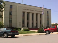
The building first used by the county as a court house, was a small wooden house which the town had erected for school purposes, and was among the first buildings erected in Oswego. After the erection of a new schoolhouse, the town donated the old building to the county for a court house, which, with a small addition that was built to it, served as a court house until the erection of the new court house, in the early part of 1880. The old house, however, was insufficient for the accommodation of all the offices, part of which were kept in whatever place could be secured suitable for the purpose.
The new court house building, a moderately large, plain, two-story brick structure, was built by the citizens of Oswego, and donated to the county.
The first term of the District Court for Labette County began October 7, 1867, with William Spriggs, Judge; R. S. Cornish, Clerk; Benjamin A. Rice, Sheriff, and D. W. Clover, Deputy Clerk. The first case tried was that of J. P. May vs. John Staginwall, and was an appeal from the Court of James Logan, Justice of the Peace. The first case brought in the District Court, was that of Jesse A. Shoat against Mary A. Shoat, for divorce, which was withdrawn by the plaintiff, the costs being taxed against him. H. C. Cook was elected Clerk of the District Court, in the fall of 1874, and has since succeeded to the office at each recurring election.
Schools and County Societies
Nothing speaks more highly for the intelligence and progressive spirit of the settlers of Labette County than the early attention they gave toward establishing schools. No sooner had a few gathered together than a school of some sort was provided and maintained for the intellectual training of the youth. And among the first buildings to be erected was that great indicator of material and mental progress, the schoolhouse. As early as 1867 a district was unofficially organized, which included within its limits the town of Oswego, in which a school was taught by Mrs. Herbaugh, and was the first school taught in Labette County.
The house in which it was kept stood on Tibbett's farm, in the south part of the town. The building was made of logs, and without a floor, except the bare earth, with rude seats and no desks. Owing to sickness among the pupils the school was broken up before the expiration of the term. This school, although the first in the county, was not the first public school. With the organization of the county, J. F. Newton held the office of County Superintendent, by appointment of the Governor of the State. Immediately on entering upon the duties of the office he officially organized school districts in the east part of the county, numbered from one to twenty-five inclusive; some of which became disorganized from time to time, which upon re-organization disarranged the order of time in which the respective formations took place.
The district in which Oswego is situated being the first organized, became No. 1, and in which the first public school was taught by Robert Elliott, at a salary of $50 per month. No school building had been erected, and a small frame house was rented, and a "frolic" was made to fit it up, or rather supply furniture suitable for the necessities of the school. Among the tools brought for the construction was a two-inch auger, with which holes were bored in the rough planks and legs supplied; the planks hitherto resting upon large stones. In this way seating was provided, and the school building furnished.
The second school taught in the county was in a little log house on Big Hill Creek, about midway between Cherryvale and Mound Valley, and was district No. 19, one of the twenty-five first established by Superintendent Newton.
The organization of districts did not correspond with any regular territorial lines but as a general rule, followed upon streams where the earliest settlements were made. In 1867, seventy-three children attended school, fifteen of whom attended subscription school, and fifty-eight in the public schools. In 1879, twelve years later, there were ninety-seven school districts, and a school population of 7,273, and in 1882, there were 105 organized districts, and a population of 8,661, having an enrollment of 7,062, and an average daily attendance of 4,045, under the instruction of 130 teachers. Thus is seen that in a period of three years following 1879, the gain in the school population was more than 1,000 in number.
County institutes were early begun for the training of teachers to greater efficiency in their work. The first effort made in this direction was in 1869, when Robert Elliott was County Superintendent. It was held in a small frame, now used as a carpenter shop, and was both an interesting and profitable session, with about thirty teachers present, and several valuable instructors. These institutes have since been held annually and are liberally attended and supported.
The Labette County Agricultural Society was formed in 1871; J. M. Wood was elected president of the association, C. B. Woodford, secretary, and C. O. Perkins, treasurer. Shortly after the organization was perfected, the exhibition grounds, comprising twenty-two and a half acres, were procured. These grounds have been fitted up as the means would justify. They are enclosed by a tight board fence, and supplied with floral hall, amphitheatre and other necessary buildings, and contain an excellent speed ring. Annual fairs have been held since the society was organized, and creditable displays have been made. C. Montague is now president of the association; C. A. Wilkin, secretary, and I. W. Patrick, treasurer. Much interest is manifested in the enterprise, which serves materially in stimulating and promoting a more exalted idea of agriculture, both theoretical and practical.
The Labette County Historical Society was organized July 16, 1878, through the exertions of Nelson Case, W. A. Starr and R. M. Donley, who were designated, by a few of the oldest settlers, a committee to take the necessary preliminary steps. At the date of its formation, the society embraced only about a dozen members. The original officers were: Nelson Case, president; George Lisle, vice-president, both of Chetopa; J. S. Waters, of Oswego, secretary; M. W. Reynolds, of Parsons, corresponding secretary; C. M. Monroe, of Fairview, treasurer. The present officers are: Nelson Case, president; W. A. Starr, secretary; T. C. Cory, treasurer; Wesley Farrot, of Elm Grove, and B. W. Perkins, of Oswego, directors. The society was incorporated November 21, 1881.
Among the early settlers interested in this society, may be named: A. T. Dickerman, who was a trader with the Indians, a resident of Fairview Township; M. M. Kingsbury, druggist, who came in 1865 or 1866, Oswego; C. C. Clover, John Clover, Bowman Altamont, the Hyatts, John Richardson, J. F. Hill, N. M. Purviance, J. D. Conderman, A. G. Drake and J. A. Gates. Stated meetings are held in the city of Oswego, Kan., on the first Wednesday of each regular term of the District Court, and special meetings at the call of the executive committee or vote of the society. Their rules are, of course, subject to change by proper methods.
Statistics
According to the Assessor's returns the personal property of the county in 1882 was as follows: Horses, 4,525--value, $103,977; cattle, 5,456--value, $65,472; mules, 1,049--value, $32,546; sheep, 8,202--value, $8,541; swine, 7,408--value, $11,200; goats, 10--value, $10; farming implements, $27,197; wagons and carriages, $27,648; bonds, $6,650; stocks, $7,846; National Bank shares, $50,000; moneys, $17,460; credits, $5,561; merchandise, $138,378; notes, $25,045; mortgages, $16,352; other property, $147,914; total, $686,697--less constitutional exemption, $219,054; net taxable personal property, $467,643.
Taxable lands under cultivation, 175,120 acres; not under cultivation, 229,080 acres--aggregate value, $1,324,865; number of improved village lots 3,616; unimproved 4,558; value, $646,613; value of railroad property, $582,726.44; total value of all property, $3,021,647.44.
There were raised in 1882 the following numbers of acres of the principal crops: Winter wheat, 25,571; rye, 566; corn, 83,127; barley, 41; oats, 12,907; buckwheat, 43; potatoes--Irish, 1,030; sweet, 94; castor beans, 12,036; cotton, 130; flax, 2,004; millet and Hungarian, 5,579; pearl millet, 196; rice corn, 22. Meadow--timothy, 1684; clover, 224; prairie, 24,758; other tame grasses, 353; pasture--timothy, 318; clover, 15; other tame grasses, 765; prairie, 50,934.
Nurseries--359 acres. Number of apple trees--bearing, 154,240; not bearing, 99,210; pear trees--bearing, 6,568; not bearing, 13,051; peach trees--bearing, 162,886; not bearing, 43,852; plum--bearing, 6,456; not bearing, 6,370; cherry--bearing, 22,948; not bearing, 18,031; vineyards--144 acres, and 165 gallons of wine made.
The following are the number of rods of the different kinds of fences in the county--Board, 34,299; rail, 124,245; stone, 13,783; hedge, 707,084; wire, 135,990--total, 1,015,041, or 3,173.2 miles.
The following are the number of acres of the different varieties of forest trees so far planted: Honey locust, 3; walnut, 36; cottonwood, 102; maple, 298; other varieties, 974--total, 1,413. But little attention has as yet been paid to the culture of the osage orange tree, red cedar and catalpa. This omission will doubtless be remedied in the near future.
The population of the county in 1870 was 9,973; in 1875, 14,571; in 1878, 17,196; in 1880, 22,736, and in 1882, 25,347--distributed among the townships and cities as follows; Osage, 1,435; Walton, 619; North, 1,025; Neosho, 732; Mound Valley, 1,517; Labette, 576; Liberty, 1,117; Montana, 973; Canada, 628; Mount Pleasant, 833; Fairview, 758; Oswego, 768; Howard, 794; Elm Grove, 1,104; Hackberry, 1,103; Richland, 1,185; Parsons, 5,567; Oswego City, 3,048, and Chetopa, 1,565.
Geography
According to the U.S. Census Bureau, the county has a total area of 1,692 km² (653 mi²), of which 1,680 km² (649 mi²) is land and 12 km² (4 mi²), or 0.69%, is water.
Demographics
As of the U.S. Census in 2000, there were 22,835 people, 9,194 households, and 6,114 families residing in the county. The population density was 14/km² (35/mi²). There were 10,306 housing units at an average density of 6/km² (16/mi²). The racial makeup of the county was 89.28% White, 4.66% Black or African American, 1.95% Native American or Alaska Native, 0.32% Asian, 0.01% Pacific Islander, 1.20% from other races, and 2.58% from two or more races. Hispanic or Latino of any race were 3.07% of the population.
There were 9,194 households out of which 31.20% had children under the age of 18 living with them, 52.10% were married couples living together, 10.20% had a female householder with no husband present, and 33.50% were non-families. 29.80% of all households were made up of individuals and 14.30% had someone living alone who was 65 years of age or older. The average household size was 2.39 and the average family size was 2.95.
In the county the population was spread out with 25.70% under the age of 18, 8.70% from 18 to 24, 25.80% from 25 to 44, 22.50% from 45 to 64, and 17.30% who were 65 years of age or older. The median age was 38 years. For every 100 females there were 95.70 males. For every 100 females age 18 and over, there were 92.00 males.
The median income for a household in the county was $30,875, and the median income for a family was $37,519. Males had a median income of $29,043 versus $21,706 for females. The per capita income for the county was $15,525. About 8.90% of families and 12.70% of the population were below the poverty line, including 14.70% of those under age 18 and 11.90% of those age 65 or over.
Cities and towns
Incorporated cities
Name and population (2005 estimate):
Parsons, 11,212
Oswego, 1,996 (county seat)
Chetopa, 1,231
Altamont, 1,065
Edna, 422
Mound Valley, 414
Bartlett, 124
Labette, 68
Unincorporated places
Angola
Dennis
Montana
Strauss
Valeda
Education
Unified school districts
Cherokee USD 247
Parsons USD 503
Oswego USD 504
Chetopa-St. Paul USD 505
Labette County USD 506
|
|
|