Early History of Ford County
by William G. Cutler (1883)
Ford County is the southwesternmost (sic) organized county of Kansas, embracing Townships 25, 26, 27, 28 and 29 of Ranges 21, 22, 23, 24, 25 and 26, being thirty miles from north to south and thirty-six miles from east to west, possessing an area of 1,080 square miles.
The country is comparatively level, 20 per cent of the land, being bottom land, - which along the Arkansas has an average width of fifteen miles; the upland is 80 per cent, and but a small portion of it is bluffy. Good building stone is found in the county contiguous to Fort Dodge, and near Spearville is found good sand and a good quality of limestone. The county is well watered, the Arkansas River flowing forty miles through the county, and other smaller streams coursing through it in various directions. The most important of these are Mulberry, Five-Mile, Kiowa, Spring and Crooked creeks. Timber is very scanty; what there is, is mostly cottonwood and box elder. These kinds are mostly grown on the timber claims. The county was named for Col. James H. Ford, of the Second Colorado Cavalry.
Organization and County Officers
Governor Thomas A. Osborn, in his proclamation providing for the organization of Ford County, on April 5, 1873, appointed Charles Rath, J. G. McDonald and Daniel Wolf special County Commissioners, and Herman J. Fringer special County Clerk. This body met at Dodge City and made choice of Charles Rath as Chairman of the Board. James Hanrahan was appointed Commissioner in place of Mr. Wolf, who was not in the county. An election for county officers was ordered June 5, 1873, and at that election the following named persons were elected, the first body of officers for Ford County: Charles Rath, A. C. Myers and F. C. Zimmerman, County Commissioners; Herman J. Fringer, County Clerk and Clerk of the District Court; A. J. Anthony, County Treasurer; Chas. E. Bassett,. Sheriff; T. L. McCarty, Coroner; H. Armitage, Register of Deeds; George B. Cox, Probate Judge; M. V. Cutter, County Attorney. M. Collar was Trustee of Dodge Township; P. T. Bowen and Thomas C. Nixon, Justices of the Peace.
A. C. Myers was selected Chairman of this Board; M. V. Cutter resigned the position of County Attorney, and was appointed Commissioner vice Rath, resigned July 24, 1873; M. V. Cutter was appointed Chairman vice Myers. The county was divided into two municipal townships. Dodge Township embraced Township 26, Range 25; Ford Township, the rest of Ford County.
The first county warrants were issued on claims growing out of a Coroner's inquest on the supposed body of Michael Stanton. T. L. McCarty was allowed $25 for professional fees as Coroner; October 6, 1873, county warrants were issued to meet the expenses incurred on holding a Coroner's inquest on the body of William Ellis and of Mrs. M. Bradley. The salary of the County Clerk was set at $250 per year.
Ford County was at first the One Hundred and Third Representative District; by the Legislative apportionment of 1876, it became the One Hundred and Twenty-second; by that of 1881, it was the One Hundred and Eighteenth District. It is the southwest organized county of the Thirty-fifth Senatorial District which elects a Senator in 1884. The district embraces the organized counties of Barber, Pratt, Stafford, Pawnee, Edwards, Ford, Hodgeman and Ness, and the unorganized counties of Lane, Scott, Wichita, Greeley, Hamilton, Kearney, Sequoyah, Gray, Arapahoe, Grant, Stanton, Kansas, Stevens, Seward, Meade, Clark and Comanche, making in all twenty-five counties, nearly one-fourth of the area of the State.
Statistics. - Ford County is in the Arkansas Valley Land District, the office of which is located at Larned, Pawnee County; Charles A. Morris, Register; Henry Booth, Receiver. It has 31,360 acres of public land, 322,560 acres of Osage Indian Trust lands, 91,917 acres of the Atchison, Topeka & Santa Fe Railroad lands, the average price of which per acre is $3.25. In 1874, there were 120,061 taxable acres; under cultivation, 95; value of the crop, $230. The people were short of breadstuffs; they had a surplus of buffalo meat. No fall wheat was sown for fear of the grasshoppers and drought. Though there were 35 families, numbering 150 persons, who might require assistance, it was reported that they would get along if "buffaloes remain and Indians stay away." In that event, said Mr. Isaac Young, "We are a free and happy people."
A Slightly Later History of Ford County
by Frank W. Blackmar (1912)
Ford County, located in the southwestern part of the state, is in the second tier of counties north of the line dividing Kansas from Oklahoma, and the fifth county east from the Colorado state line. It is bounded on the north by Hodgeman county, east by Edwards and Kiowa, south by Clark and Meade and west by Gray, and has an area of 1,080 square miles. Ford county was created by the act of 1867, which provided for the division into counties of all the unorganized part of the state east of range 26 west, and was named in honor of Col. James H. Ford of the Second Colorado cavalry. It was not organized until 1873.
One of the first parties to travel westward through this portion of Kansas with a pack train was the McKnight expedition in 1812, which followed the Arkansas river. A few years later Maj. Stephen H. Long's expedition passed up the Arkansas valley and by 1825 this route became known as the "Santa Fe Trail". One of the earliest military posts in Kansas was located in what is now Ford county. Fort Dodge, established in 1864, was on the north bank of the Arkansas, about 2 miles east of Dodge City. The old military reservation is now the site of the State Soldiers' Home.
During the rush to California in 1849 thousands of gold seekers passed along the Santa Fe trail, through what is now Ford county, but few located there. Among the first permanent settlers were A. J. Anthony, who located on a ranch 20 miles west of Dodge City, in 1867. He kept a few cattle and a general store for a year, then moved to Fort Dodge and engaged in the sutler business until 1874. Herman J. Fringer came to Fort Dodge in 1867 as quartermaster's clerk. Later he opened one of the pioneer drug stores and served as justice of the peace before the county was organized. H. L. Sitler came to the county in 1868, and was one of the pioneer freighters, before the railroad was built. Dodge City grew up not far from the fort.
In a few years the frontier moved further west and Ford county became populated with industrious husbandmen, who established permanent homes and prosperous farms. On April 5, 1873, Gov. Osborn issued a proclamation providing for the organization of Ford county. He appointed Charles Rath, J. G. McDonald and Daniel Wolf as special commissioners, and Herman J. Fringer as special clerk. The commissioners met at Dodge City and elected Charles Rath chairman. James Hanrahan was appointed special commissioner in place of Daniel Wolf, who was not in the county. An election for county officers was ordered for June 5, 1873, when the following persons were elected: Charles Rath, A. C. Meyers and F. C. Zimmerman, commissioners; Herman J. Fringer, county clerk, and also clerk of the district court; A. J. Anthony, treasurer; H. Armitage, register of deeds; George B. Cox, probate judge; M. V. Cutler, county attorney; Charles E. Bassett, sheriff, and T. L. McCarty, coroner. P. T. Bowen and Thomas C. Nixon were elected justices of the peace in the two civil townships, Dodge and Ford. At the election on Nov. 4, 1873, A. J. Anthony, A. J. Peacock and Charles Rath were elected commissioners; William F. Sweney, clerk; M. T. Bruin, register of deeds; George B. Cox, probate judge; L. D. Henderson, county attorney; M. Collar, superintendent of public instruction; John McDonald, clerk of the district court; A. B. Webster, treasurer; Charles E. Bassett, sheriff; T. L. McCarty, coroner; John Kirby, surveyor, and James Hanrahan, representative to the state legislature.
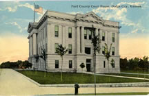
In 1874, the old toll house was taken for a county poor-house. Up to 1875 rented buildings were used for court-house purposes and the county offices, but during the summer of 1876, a fine brick court-house was completed at a cost of $8,000, and all the county offices and records were removed to it.
One of the earliest newspapers in the county was the Dodge City Messenger, established in Feb., 1874, by A. W. Moore, but the paper was suspended in 1875. On May 20, 1876, the Dodge City Times made its appearance. It was founded by Lloyd and Walter C. Shinn, and the Ford County Globe was started at Dodge City in Dec., 1877, by William N. Morphy and D. M. Frost. The Methodists, Baptists, Episcopalians and Catholics all have churches in the county, most of them substantial edifices.
The surface of the county is generally level. Practically all the bottom land in the county is the valley of the Arkansas river, which varies from one to two miles in width and comprises about one-tenth of the area of the county.There is very little native timber, and what there is consists of narrow belts along the streams. The cottonwood is the most numerous, but hackberry, walnut and cedar are found. The Arkansas river enters the county about 8 miles south of the northwest corner, flows southeast nearly to the eastern boundary and thence northeast into Edwards county.
Its most important tributary is Mulberry creek. Saw Log creek, a branch of the Pawnee, flows through the northern section. Magnesian limestone of good quality exists near Dodge City, and sandstone is found in the bluffs along the Arkansas river. Gypsum is common in the northern portion, along Saw Log creek. Winter wheat, barley, oats and corn are the leading grains, Kafir corn, alfalfa and sorghum are extensively raised, and the county ranks high in live stock.
Excellent transportation facilities are afforded by the main line of the Atchison, Topeka & Santa Fe railroad, which enters in the northeast corner, passes southwest to Dodge City, and thence west along the Arkansas river. The main line of the Chicago, Rock Island & Pacific railroad crosses the southeast corner, and there are nearly 90 miles of main track railroad within the bounds of the county, which is divided into the following townships: Bloom, Bucklin, Concord, Dodge, Enterprise, Fairview, Ford, Grandview, Pleasant Valley, Richland, Royal, Sodville, Spearville, Wheatland and Wilburn. The population in 1910 was 11,393, a gain of 5,896, or more than 100 per cent. during the preceding decade. The assessed valuation of property for that year was $19,040,450, and the value of all farm products, including live stock, was nearly $3,500,000.
Geography
According to the U.S. Census Bureau, the county has a total area of 2,847 km² (1,099 mi²), of which 2,845 km² (1,098 mi²) is land and 2 km² (1 mi²), or 0.07%, is water.
Demographics
Ford County's population was estimated to be 33,783 in the year 2006, an increase of 1183, or +3.6%, over the previous six years.
As of the U.S. Census in 2000, there were 32,458 people, 10,852 households, and 7,856 families residing in the county. The population density was 11/km² (30/mi²). There were 11,650 housing units at an average density of 4/km² (11/mi²). The racial makeup of the county was 74.85% White, 1.62% Black or African American, 0.63% Native American, 2.05% Asian, 0.12% Pacific Islander, 18.17% from other races, and 2.56% from two or more races. Hispanic or Latino of any race were 37.68% of the population.
There were 10,852 households out of which 40.90% had children under the age of 18 living with them, 57.90% were married couples living together, 9.20% had a female householder with no husband present, and 27.60% were non-families. 22.70% of all households were made up of individuals and 9.50% had someone living alone who was 65 years of age or older. The average household size was 2.92 and the average family size was 3.42.
In the county the population was spread out with 31.10% under the age of 18, 11.20% from 18 to 24, 29.40% from 25 to 44, 17.30% from 45 to 64, and 11.00% who were 65 years of age or older. The median age was 30 years. For every 100 females there were 107.20 males. For every 100 females age 18 and over, there were 105.30 males.
The median income for a household in the county was $37,860, and the median income for a family was $42,734. Males had a median income of $27,189 versus $22,165 for females. The per capita income for the county was $15,721. About 9.90% of families and 12.40% of the population were below the poverty line, including 15.40% of those under age 18 and 8.40% of those age 65 or over.
Cities and towns
Incorporated cities
Name and population (2004 estimate):
Dodge City, 25,762 (county seat)
Spearville, 845
Bucklin, 722
Ford, 325
Unincorporated places
Bellefont
Bloom
Ft. Dodge
Howell
Kingsdown
Wilroads
Wilroads Gardens
Windhorst
Wright
Education
Unified school districts
Spearville USD 381
Dodge City USD 443
Bucklin USD 459
|