Early History of Oberlin
By Frank W Blackmar (1912)
Oberlin, the county seat of Decatur county, is an incorporated city of the third class, located a little northwest of the center, on Sappa creek and at the terminus of a branch of the Chicago, Burlington & Quincy R. R. It has electric lights, waterworks, fire department, sewer system, an opera house, flour mill, foundry, creamery, grain elevators, county high school, public library, 2 banks, 3 newspapers (the Times, the Herald and the News), telegraph and express offices, and an international money order postoffice with six rural routes.
The population in 1910 was 1,157. The town was platted in 1878, and in September of that year consisted of two stores, a hotel and a blacksmith shop. In 1882 the population was 300. In 1885 Oberlin was incorporated as a city of the third class. The population in 1890 was 976. In 1882 the independent volunteer cavalry company of Oberlin was organized. Oberlin is in the midst of a prosperous farming district for which it is the receiving and shipping point.
Early History of Oberlin
by William G. Cutler (1883)
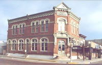
Oberlin, the county seat and principal town of Decatur County, is situated near the geographical center of the County, on section 1, town 3, range 29. The site was preempted in 1873 by John A. Rodehaver. The plat was laid out in 1878, and in September of that year the village consisted of one sod and one frame store, a log hotel and a log blacksmith shop. A frame and a sod house were also in process of construction. Mr. Van Wormer opened the first general store, but soon sold his stock to J. W. Allen & Son. R. A. Marks was the next man who ventured in the mercantile trade, and subsequently became engaged in banking. Business of almost every kind is now started in the place.
The population numbers about 300, and the school report for the month ending February 8, 1883, shows 36 pupils in the primary grade and 31 pupils in the higher department. The first birth in the town was a son to Mr. and Mrs. J. W. Allen, January 7, 1879.
There is a daily mail from Oberlin to Grainfield, Gove County, which leaves at 6 A. M., arrives at 6 P. M. One from Oberlin to Indianola, the county seat of Red Willow County, Nebraska, on the B. & M. railroad; one from Oberlin to Lenora, Norton County, the terminus of the C. B. division of the Missouri Pacific. There is a semi-weekly mail from Oberlin to Colby; a tri-weekly from Oberlin to Norton, and one from Oberlin to Atwood, the count seat of Rawlins. By an arrangement effected in February, 1883, all mail for Oberlin, east of the Missouri River is transferred to Atchison, thus advancing it three hours.
The Independent Volunteer Cavalry Company (State Militia) of Oberlin was organized December 12, 1882. The company numbers thirty, with L. G. Parker as First Lieutenant. Oberlin now has two church organizations, John Wilson being the Presbyterian minister and I. L. Day, the Methodist. There is one hotel, J. A. Rodehaver, proprietor; a bank, R. A. Marks, banker; one newspaper, the Oberlin Herald, W. D. Street, editor; eighteen or twenty stores and shops of various kinds and a full corp of lawyers and physicians. Wm. Hollowell is postmaster.
The Northern Land District is taken from the Northwestern district, and its office is at Oberlin. Thomas H. Cavanaugh, register; Charles E. Chandler, receiver; Edmund Martin, chief clerk. The district comprises 3,878,400 acres of land, the larger portion of it subject to settlement, as except its school lands, and that already taken by settlers. About ten per cent of it is open. Decatur, Rawlins, Cheyenne, Sherman, Thomas, Sheridan, Graham and Norton Counties, all have to do with the Land office at Oberlin.
Geography
Oberlin is located at 39°49'16N, 100°31'42W (39.821235, -100.528369).
According to the United States Census Bureau, the city has a total area of 5.0 km² (1.9 mi²), all land.
Demographics
As of the census of 2000, there were 1,994 people, 879 households, and 550 families residing in the city. The population density was 401.0/km² (1,039.7/mi²). There were 1,048 housing units at an average density of 210.7/km² (546.5/mi²). The racial makeup of the city was 97.79% White, 0.25% African American, 0.15% Native American, 0.20% Asian, 0.05% Pacific Islander, 0.25% from other races, and 1.30% from two or more races. Hispanic or Latino of any race were 1.15% of the population.
There were 879 households out of which 25.8% had children under the age of 18 living with them, 51.8% were married couples living together, 7.6% had a female householder with no husband present, and 37.4% were non-families. 36.2% of all households were made up of individuals and 20.7% had someone living alone who was 65 years of age or older. The average household size was 2.15 and the average family size was 2.78.
In the city the population was spread out with 22.6% under the age of 18, 5.1% from 18 to 24, 21.0% from 25 to 44, 21.4% from 45 to 64, and 29.9% who were 65 years of age or older. The median age was 46 years. For every 100 females there were 85.1 males. For every 100 females age 18 and over, there were 79.3 males.
The median income for a household in the city was $30,816, and the median income for a family was $34,583. Males had a median income of $27,177 versus $16,488 for females. The per capita income for the city was $17,271. About 5.0% of families and 6.8% of the population were below the poverty line, including 7.1% of those under age 18 and 4.4% of those age 65 or over.
|